


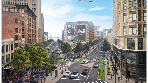
The curious case of Cleveland's new "buffered" bike lanes. The question: Why are the buffers placed between the bike lane and the curb?
"Cleveland is finally installing buffered bike lanes along some major streets, but with the buffer between the bike lane and the curb, not between the bike lane and traffic," reports Angie Schmitt.
Schmitt, along with blogger Marc Lefkowitz, have been digging into the configuration to discover why the buffer wasn't placed between the bike lane and the vehicle lane, as with most buffered lanes. Lefkowtiz gained access to an email between Cleveland traffic engineer, Andy Cross, and the advocacy group Bike Cleveland, in which Cross explains his decision about the configuration:
"The terms 'best practices' and 'protected' are often used with what is shown in the NACTO guide...A design that encourages or requires hook turns across the path of through cyclists is neither a 'best practice' nor ‘protected.'"
Schmitt notes that Cleveland's design decision is unconventional enough that some have speculated the configuration "was lifted not from a design manual but from Iamtraffic.org, a website that espouses vehicular cycling." The concern with the decision, according to Schmitt, is that "ineffective design threatens to sabotage the usefulness of the new infrastructure."
FULL STORY: Cleveland Traffic Engineer Puts Buffer on the Wrong Side of the Bike Lane


Reactions to Cleveland's Backwards Bike Lane
A photo of a "backwards" buffered bike lane in Cleveland prompts commentary from the planning community. What is gained by separating bike lane and curb?
Downtown Cleveland Gets First Ever Protected Bike Lanes
The $200,000 “quick build” lanes are the first of 50 planned miles over five years.
Cleveland To Build First Protected Downtown Bike Lane
The city is taking steps to build out a more comprehensive bike lane network to connect downtown destinations.

Planetizen Federal Action Tracker
A weekly monitor of how Trump’s orders and actions are impacting planners and planning in America.

Map: Where Senate Republicans Want to Sell Your Public Lands
For public land advocates, the Senate Republicans’ proposal to sell millions of acres of public land in the West is “the biggest fight of their careers.”

Restaurant Patios Were a Pandemic Win — Why Were They so Hard to Keep?
Social distancing requirements and changes in travel patterns prompted cities to pilot new uses for street and sidewalk space. Then it got complicated.

DC Area County Eliminates Bus Fares
Montgomery County joins a growing trend of making transit free.

Platform Pilsner: Vancouver Transit Agency Releases... a Beer?
TransLink will receive a portion of every sale of the four-pack.

Toronto Weighs Cheaper Transit, Parking Hikes for Major Events
Special event rates would take effect during large festivals, sports games and concerts to ‘discourage driving, manage congestion and free up space for transit.”
Urban Design for Planners 1: Software Tools
This six-course series explores essential urban design concepts using open source software and equips planners with the tools they need to participate fully in the urban design process.
Planning for Universal Design
Learn the tools for implementing Universal Design in planning regulations.
Heyer Gruel & Associates PA
JM Goldson LLC
Custer County Colorado
City of Camden Redevelopment Agency
City of Astoria
Transportation Research & Education Center (TREC) at Portland State University
Camden Redevelopment Agency
City of Claremont
Municipality of Princeton (NJ)