


A new online visualization tool makes it easier to read and understand data about mobile phone usage in four cities around the world, including Los Angeles and New York.
According to a post on MIT Technology Review, the SENSEable City Laboratory, part of MIT, and Ericsson, a network infrastructure technology company, have unveiled an online tool that "uses mobile phone data to visualize human activity in cities all over the world."
The ManyCities tool, as it's called, "[gathers] mobile phone data from base stations across the cities of Los Angeles, New York, London, and Hong Kong between April 2013 and January 2014. The data includes the number of calls placed, the number of text messages sent, the amount of data downloaded and uploaded and the number of data requests at 15-minute intervals."
As an example of how the ManyCities visualization tool could be used, a Los Angeles civic enthusiast might peruse the site surprised to discover that the highest density of call activity in the city is located in Koreatown and Westlake.
The team behind ManyCities also presented the tool in the July issue of the Landscape Architecture Frontiers journal.
FULL STORY: The Website That Visualizes Human Activity in Cities Across the World

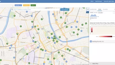
Presenting Municipal Data in an Interactive Map, Nashville Style
The city of Nashville launched the NashView interactive data map earlier this month.

DataUSA: An Intuitive Tool for Public Data
A collaboration between Deloitte, Datawheel, and MIT has produced an intuitive aesthetically-pleasing gathering point for public data in the United States. Specific locations and industries boast easy-to-read profiles.
Mapped: Every Building in the United States
Using data from Microsoft, the New York Times has published an online map showing the placement of every building in the country, in a simple black and white format.

Planetizen Federal Action Tracker
A weekly monitor of how Trump’s orders and actions are impacting planners and planning in America.

San Francisco's School District Spent $105M To Build Affordable Housing for Teachers — And That's Just the Beginning
SFUSD joins a growing list of school districts using their land holdings to address housing affordability challenges faced by their own employees.

The Tiny, Adorable $7,000 Car Turning Japan Onto EVs
The single seat Mibot charges from a regular plug as quickly as an iPad, and is about half the price of an average EV.

As Trump Phases Out FEMA, Is It Time to Flee the Floodplains?
With less federal funding available for disaster relief efforts, the need to relocate at-risk communities is more urgent than ever.

With Protected Lanes, 460% More People Commute by Bike
For those needing more ammo, more data proving what we already knew is here.

In More Metros Than You’d Think, Suburbs are Now More Expensive Than the City
If you're moving to the burbs to save on square footage, data shows you should think again.
Urban Design for Planners 1: Software Tools
This six-course series explores essential urban design concepts using open source software and equips planners with the tools they need to participate fully in the urban design process.
Planning for Universal Design
Learn the tools for implementing Universal Design in planning regulations.
Smith Gee Studio
City of Charlotte
City of Camden Redevelopment Agency
City of Astoria
Transportation Research & Education Center (TREC) at Portland State University
US High Speed Rail Association
City of Camden Redevelopment Agency
Municipality of Princeton (NJ)