


Forget Hollywood's proclivity for destroying Los Angeles and San Francisco in movies like San Andreas—the greatest seismic threat in North America is in the Pacific Northwest.
Kathryn Schulz provides an in-depth look at an under appreciated seismic threat on the West Coast—not the San Andreas fault, but the Cascadia subduction zone. Writes Schulz: "Just north of the San Andreas, however, lies another fault line. Known as the Cascadia subduction zone, it runs for seven hundred miles off the coast of the Pacific Northwest, beginning near Cape Mendocino, California, continuing along Oregon and Washington, and terminating around Vancouver Island, Canada."
Schulz begins by citing the example of Japan's 2011 Tohoku earthquake, which reached a 9.0 on the Richter scale, to illustrate how deadly an event along the Cascadia subduction zone could be. The upper limit of Cascadia's potential is thought to be 9.2. For comparison's sake, the upper limit of the San Andreas Fault's power is estimated at 8.2.
The article goes on to describe, in vivid detail, what would happen in the even of the "Really Big One," which experts speculate would be the worst natural disaster in North American history. According to Kenneth Murphy, who directs FEMA's Region X, "everything west of Interstate 5 will be toast." Adds Schulz: "Everything west of Interstate 5 includes "Seattle, Tacoma, Portland, Eugene, Salem (the capital city of Oregon), Olympia (the capital of Washington), and some seven million people." That would kill an estimated 13,000 people. Schulz also cites the expertise of Chris Goldfinger, who puts the odds of such an event occurring in the next 50 years at one in three.
The article concludes with in an incredible accounting of geologic history, describing the work of historians and geologists in the United States and Japan to find evidence of the last major earthquake on the Cascadia subduction zone in 1700.
FULL STORY: The Really Big One

When the Earth Turns to Liquid
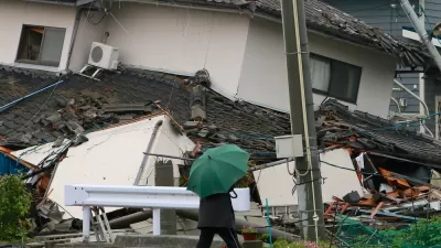
A 7.5 magnitude earthquake struck the Indonesian island of Sulawesi on Sept. 25, followed by a massive tsunami. Soil liquefaction caused by the tremor resulted in 1,700 homes being "swallowed" as the soil shifted. Deaths exceeded 1,400 on Oct. 3.
A New Earthquake Warning System for the Pacific Northwest
Oregon and Washington are implementing sensors that can detect and report an earthquake to communities with as much as a minute or two of warning.
Worst-Case Tsunami Scenario Mapped
The event of a huge earthquake off the Aleutian Islands could send a devastating tsunami towards the West coast of the U.S. Researchers have released maps of what a worst-case scenario might look like for coastal communities.

Planetizen Federal Action Tracker
A weekly monitor of how Trump’s orders and actions are impacting planners and planning in America.

Map: Where Senate Republicans Want to Sell Your Public Lands
For public land advocates, the Senate Republicans’ proposal to sell millions of acres of public land in the West is “the biggest fight of their careers.”

Restaurant Patios Were a Pandemic Win — Why Were They so Hard to Keep?
Social distancing requirements and changes in travel patterns prompted cities to pilot new uses for street and sidewalk space. Then it got complicated.

Platform Pilsner: Vancouver Transit Agency Releases... a Beer?
TransLink will receive a portion of every sale of the four-pack.

Toronto Weighs Cheaper Transit, Parking Hikes for Major Events
Special event rates would take effect during large festivals, sports games and concerts to ‘discourage driving, manage congestion and free up space for transit.”

Berlin to Consider Car-Free Zone Larger Than Manhattan
The area bound by the 22-mile Ringbahn would still allow 12 uses of a private automobile per year per person, and several other exemptions.
Urban Design for Planners 1: Software Tools
This six-course series explores essential urban design concepts using open source software and equips planners with the tools they need to participate fully in the urban design process.
Planning for Universal Design
Learn the tools for implementing Universal Design in planning regulations.
Heyer Gruel & Associates PA
JM Goldson LLC
Custer County Colorado
City of Camden Redevelopment Agency
City of Astoria
Transportation Research & Education Center (TREC) at Portland State University
Camden Redevelopment Agency
City of Claremont
Municipality of Princeton (NJ)