


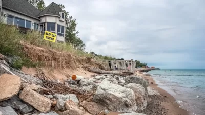
Several agencies with the city of Boston will begin studying how to retrofit the city's building codes to prepare for the impacts of climate change.
Jon Chesto reports that Boston Mayor Martin J. Walsh "has directed the Boston Redevelopment Authority and the city’s environmental services and inspectional services divisions to reduce the red tape involved with building or modifying a structure if it’s for the purpose of making it less prone to flood damage."
The order from the mayor is intended to help developers prepare for the impacts of rising seas as a result of climate change. The improvements at the ground level could have an impact at higher elevations of the city 's building stock, however. According to Chesto, "the three city agencies will determine whether it’s OK to raise height restrictions to accommodate putting mechanical systems on a higher floor, or on the roof. To avoid flood damage, electrical and HVAC systems would be located above the ground floor. But that could take away from valuable office or residential space. An extra height allowance could give owners and developers room to make up the difference."
It's possible that zoning codes that come out of a new policy could change the way buildings are measured. "In other words, a certain amount of 'flood resistant' footage wouldn’t be counted against a building’s height limit," writes Chesto.
As for existing buildings, one business owner cited by Chesto has already requested permission from the Boston Redevelopment Authority to build extra office space on the roof of a building in exchange for moving electrical systems out of the basement.
FULL STORY: Boston aims to help developers plan for rising seas


Boston Unveils New Shoreline Resilience Plan
With the news of the UN Intergovernmental Panel on Climate Change's report predicting dire consequences of climate change and seal level rise still fresh, the city of Boston has released a plan for how it will shore up its coastline.
How US Cities Can Prepare for Climate Disasters
Resilience, encompassing infrastructure, governance, economic strength, and social cohesion, is critical for cities to mitigate rising climate risks like flooding, wildfires, and heat, ensuring long-term recovery and adaptability.
Climate Change Putting Coastal Infrastructure at Risk
More than 1,000 coastal facilities could flood as often as once a month as sea levels rise, according to a study from the Union of Concerned Scientists.

Maui's Vacation Rental Debate Turns Ugly
Verbal attacks, misinformation campaigns and fistfights plague a high-stakes debate to convert thousands of vacation rentals into long-term housing.

Planetizen Federal Action Tracker
A weekly monitor of how Trump’s orders and actions are impacting planners and planning in America.

San Francisco Suspends Traffic Calming Amidst Record Deaths
Citing “a challenging fiscal landscape,” the city will cease the program on the heels of 42 traffic deaths, including 24 pedestrians.

Half of Post-Fire Altadena Home Sales Were to Corporations
Large investors are quietly buying up dozens of properties in Altadena, California, where a devastating wildfire destroyed more than 6,000 homes in January.

Opinion: What San Francisco’s Proposed ‘Family Zoning’ Could Really Mean
Mayor Lurie is using ‘family zoning’ to encourage denser development and upzoning — but could the concept actually foster community and more human-scale public spaces?

Jacksonville Launches First Autonomous Transit Shuttle in US
A fleet of 14 fully autonomous vehicles will serve a 3.5-mile downtown Jacksonville route with 12 stops.
Urban Design for Planners 1: Software Tools
This six-course series explores essential urban design concepts using open source software and equips planners with the tools they need to participate fully in the urban design process.
Planning for Universal Design
Learn the tools for implementing Universal Design in planning regulations.
Gallatin County Department of Planning & Community Development
Heyer Gruel & Associates PA
JM Goldson LLC
City of Camden Redevelopment Agency
City of Astoria
Transportation Research & Education Center (TREC) at Portland State University
Jefferson Parish Government
Camden Redevelopment Agency
City of Claremont