


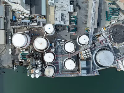
More than 1,000 coastal facilities could flood as often as once a month as sea levels rise, according to a study from the Union of Concerned Scientists.
An analysis from the Union of Concerned Scientists (UCS) highlights the growing flood risk to thousands of infrastructure facilities in coastal parts of the United States, reports Christina Andrews for WUWF.
According to the report’s authors, “nearly 1,100 basic facilities and infrastructure along the U.S. coastline would flood 12 times a year on average, or the equivalent of once a month, by 2050, assuming a medium rate of sea level rise.”
Report co-author Dr. Kristina Dahl says the analysis quantifies the impacts of climate change. “Things like wastewater treatment plants, schools, hospitals. So what we've done here is mapped out areas that will experience more frequent flooding due to sea level rise, and then mapped those out with respect to the infrastructure that's along our coasts, we are able to pinpoint when and where that infrastructure will be affected by more frequent flooding.”
The authors hope the report will spark action to protect coastal infrastructure. “One of the reasons that we wanted to look at critical infrastructure is that it's very long-lived and it takes a long time to plan and to build or to renovate,” said Dahl. “But the prospect of having that contamination not isolated and spreading out into our neighborhoods, we hope, alerts people to the real dangers that sea level rise presents. And we also know from this analysis that there is time to plan for this.”

How US Cities Can Prepare for Climate Disasters
Resilience, encompassing infrastructure, governance, economic strength, and social cohesion, is critical for cities to mitigate rising climate risks like flooding, wildfires, and heat, ensuring long-term recovery and adaptability.
New York Updating its Flood Resilience Zoning
New York City intends to make sure that zoning codes are a tool for preventing the risks of flooding.

Connecticut Shoreline Rail Vulnerable to Floods
Long stretches of Connecticut's "lifeblood" shoreline rail line lie in the path of rising seas and future floods. While moving the tracks further inland is prohibitively expensive, a resilience plan is still needed.

Maui's Vacation Rental Debate Turns Ugly
Verbal attacks, misinformation campaigns and fistfights plague a high-stakes debate to convert thousands of vacation rentals into long-term housing.

Planetizen Federal Action Tracker
A weekly monitor of how Trump’s orders and actions are impacting planners and planning in America.

In Urban Planning, AI Prompting Could be the New Design Thinking
Creativity has long been key to great urban design. What if we see AI as our new creative partner?

King County Supportive Housing Program Offers Hope for Unhoused Residents
The county is taking a ‘Housing First’ approach that prioritizes getting people into housing, then offering wraparound supportive services.

Researchers Use AI to Get Clearer Picture of US Housing
Analysts are using artificial intelligence to supercharge their research by allowing them to comb through data faster. Though these AI tools can be error prone, they save time and housing researchers are optimistic about the future.

Making Shared Micromobility More Inclusive
Cities and shared mobility system operators can do more to include people with disabilities in planning and operations, per a new report.
Urban Design for Planners 1: Software Tools
This six-course series explores essential urban design concepts using open source software and equips planners with the tools they need to participate fully in the urban design process.
Planning for Universal Design
Learn the tools for implementing Universal Design in planning regulations.
planning NEXT
Appalachian Highlands Housing Partners
Mpact (founded as Rail~Volution)
City of Camden Redevelopment Agency
City of Astoria
City of Portland
City of Laramie