


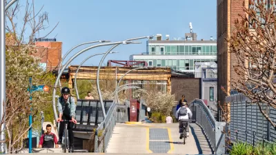
Following in the footsteps of the High Line in New York City, Chicago opened a 2.7-mile elevated park, which has already been extremely popular in its first week. Here we round up the initial reactions to The 606, as the new park is called.
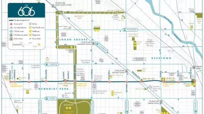
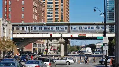
"Chicago’s long-awaited bikeway and elevated park, The 606, opened last weekend (on 6/6, no less) to a rush of pedestrians and cyclists who were eager to test out the new 2.7-mile trail after years of planning, design and construction," according to Chris Bentley.
The 606, formerly called the Bloomingdale Trail, "is as much a highway for bikes as anything else, due in part to its having been largely funded through the U.S. Department of Transportation’s Congestion Mitigation and Air Quality (CMAQ) improvement program."
Steven Vance created a time-lapse video of the entire length of The 606, which you can watch here. Vance also wrote for Streetsblog Chicago to explain how he made the video.
Bicycling west to east on the Bloomingdale Trail from Steven Vance on Vimeo.
Writing for Landscape Architecture Magazine, Zach Mortice offers more details about the funding and political support necessary for the park as well as more details about the design of the route.
FULL STORY: RIDE CHICAGO’S NEW ELEVATED PARK AND BIKE PATH, THE 606, WITH THIS TIME-LAPSE VIDEO

Bloomingdale Trail Gets New Name and Final Plan
Final plans for what will become the longest elevated park in the world where unveiled this week in Chicago. The 2.7-mile rail-to-trail conversion has been branded as The 606, a nod to the zip code digits shared by the neighborhoods along its route.
Chicago's New Strategic Plan for Transportation Prioritizes Equity and Accountability
The plan calls for safer streets, more equitable distribution of resources, and expanded community engagement.
Don't Call it The 606: Chicago's Popular Linear Park Gets a New Name
The Chicago Park District wants to be extra sure we're all clear on this.

Planetizen Federal Action Tracker
A weekly monitor of how Trump’s orders and actions are impacting planners and planning in America.

San Francisco's School District Spent $105M To Build Affordable Housing for Teachers — And That's Just the Beginning
SFUSD joins a growing list of school districts using their land holdings to address housing affordability challenges faced by their own employees.

The Tiny, Adorable $7,000 Car Turning Japan Onto EVs
The single seat Mibot charges from a regular plug as quickly as an iPad, and is about half the price of an average EV.

Seattle's Plan for Adopting Driverless Cars
Equity, safety, accessibility and affordability are front of mind as the city prepares for robotaxis and other autonomous vehicles.

As Trump Phases Out FEMA, Is It Time to Flee the Floodplains?
With less federal funding available for disaster relief efforts, the need to relocate at-risk communities is more urgent than ever.

With Protected Lanes, 460% More People Commute by Bike
For those needing more ammo, more data proving what we already knew is here.
Urban Design for Planners 1: Software Tools
This six-course series explores essential urban design concepts using open source software and equips planners with the tools they need to participate fully in the urban design process.
Planning for Universal Design
Learn the tools for implementing Universal Design in planning regulations.
Smith Gee Studio
City of Charlotte
City of Camden Redevelopment Agency
City of Astoria
Transportation Research & Education Center (TREC) at Portland State University
US High Speed Rail Association
City of Camden Redevelopment Agency
Municipality of Princeton (NJ)