


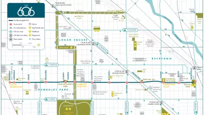
Final plans for what will become the longest elevated park in the world where unveiled this week in Chicago. The 2.7-mile rail-to-trail conversion has been branded as The 606, a nod to the zip code digits shared by the neighborhoods along its route.
"The planned 2.7-mile Bloomingdale Trail and five linked parks -- envisioned as an elevated pedestrian and bicycling corridor splashed with artwork and landscaping -- will assume a new, overarching identity Tuesday when the multi-use recreation system assumes a fresh moniker: The 606." reports Kathy Bergen. "The 606 label represents something virtually all city residents share -- the first three digits of Chicago ZIP codes, which planners hope will connote unity and links among neighborhoods."
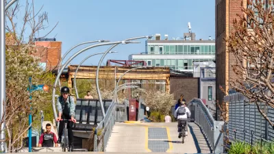
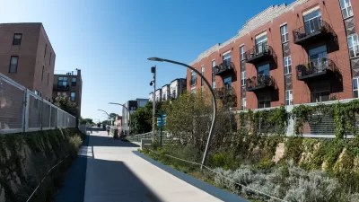
In preparation for the project's August groundbreaking, the final plans and implementation schedule were presented at a public meeting held Tuesday. "To start, 38 bridges along the tracks will have to be repaired and rehabilitated, which will result in the some weekend road closures including Ashland, Western and Milwaukee avenues," reports Victoria Johnson. "Attendees also got sneak previews of other plans for The 606 [PDF], including a skate park, event center and stage and an observatory designed to line up with the setting sun."
"The development of a project name came about to dispel confusion surrounding the trail, which will run atop an abandoned 16-foot-high rail bed that runs above Bloomingdale Avenue, which is about 1800 [sic] north," says Bergen. "It stretches from Ashland Avenue on the east to Ridgeway Avenue on the west, linking Bucktown, Wicker Park, Logan Square and Humboldt Park."
"Lots of people thought it was in Bloomingdale, Ill., or many times people would call it the Bloomington Trail," said Beth White, director of the Trust for Public Land's Chicago office.
FULL STORY: Next step for Bloomingdale Trail: Creating an identity

Meet the 606: Chicago's New Elevated Bikeway and Park
Following in the footsteps of the High Line in New York City, Chicago opened a 2.7-mile elevated park, which has already been extremely popular in its first week. Here we round up the initial reactions to The 606, as the new park is called.
Don't Call it The 606: Chicago's Popular Linear Park Gets a New Name
The Chicago Park District wants to be extra sure we're all clear on this.
More Cities Pressing Pause on Development as Gentrification, Displacement Concerns Persist
Chicago and Atlanta both approved development moratoriums in areas surrounding new urban amenities this year. Other cities could soon add to the number.

Maui's Vacation Rental Debate Turns Ugly
Verbal attacks, misinformation campaigns and fistfights plague a high-stakes debate to convert thousands of vacation rentals into long-term housing.

Planetizen Federal Action Tracker
A weekly monitor of how Trump’s orders and actions are impacting planners and planning in America.

San Francisco Suspends Traffic Calming Amidst Record Deaths
Citing “a challenging fiscal landscape,” the city will cease the program on the heels of 42 traffic deaths, including 24 pedestrians.

Defunct Pittsburgh Power Plant to Become Residential Tower
A decommissioned steam heat plant will be redeveloped into almost 100 affordable housing units.

Trump Prompts Restructuring of Transportation Research Board in “Unprecedented Overreach”
The TRB has eliminated more than half of its committees including those focused on climate, equity, and cities.

Amtrak Rolls Out New Orleans to Alabama “Mardi Gras” Train
The new service will operate morning and evening departures between Mobile and New Orleans.
Urban Design for Planners 1: Software Tools
This six-course series explores essential urban design concepts using open source software and equips planners with the tools they need to participate fully in the urban design process.
Planning for Universal Design
Learn the tools for implementing Universal Design in planning regulations.
Heyer Gruel & Associates PA
JM Goldson LLC
Custer County Colorado
City of Camden Redevelopment Agency
City of Astoria
Transportation Research & Education Center (TREC) at Portland State University
Jefferson Parish Government
Camden Redevelopment Agency
City of Claremont