


A city known for its love of the automobile has been building out its bike network in recent years. The question remains: Is it enough?
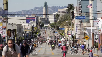
Following an unflattering portrayal of the state of bike infrastructure in Los Angeles, by reporter Aaron Mendelson, the Los Angeles Department of Transportation released new data enabling Mendelson and the KPCC team to create an animated map showing the expansion of the city's bike infrastructure network between the years 2006 and 2015.
First the backstory:
"The LADOT maintains a bike map on its website, but doesn't typically release the raw data behind it to the public. But for this story, the agency shared the latest data—current as of April 1—and we're posting it to Github."
As for what the new data and animated map show: "in 2005, the city of Los Angeles had 245 miles of bike infrastructure: bike lanes, bike paths and streets where drivers are alerted to share the road by bike signs and markings….In the decade since then, the system had more than doubled to 562.25 miles of bike lanes, paths and routes."
Mendelson notes that not all bike infrastructure is created equal, and some parts of the existing network would still likely be deemed unsafe to many potential riders.
FULL STORY: Watch a decade of growth in LA's bike infrastructure

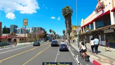
New Bike Lanes Coming to Hollywood Boulevard
Los Angeles is adding 3.6 miles of new protected bike lanes in East Hollywood.

Los Angeles Approves Road Safety Measure
Voters expressed strong support for road safety improvements.

LA’s Mobility Plan Implementation Faces Opposition
The city’s firefighters’ union claims that bike and bus lanes would slow response times and impede access for first responders.

Maui's Vacation Rental Debate Turns Ugly
Verbal attacks, misinformation campaigns and fistfights plague a high-stakes debate to convert thousands of vacation rentals into long-term housing.

Planetizen Federal Action Tracker
A weekly monitor of how Trump’s orders and actions are impacting planners and planning in America.

In Urban Planning, AI Prompting Could be the New Design Thinking
Creativity has long been key to great urban design. What if we see AI as our new creative partner?

King County Supportive Housing Program Offers Hope for Unhoused Residents
The county is taking a ‘Housing First’ approach that prioritizes getting people into housing, then offering wraparound supportive services.

Researchers Use AI to Get Clearer Picture of US Housing
Analysts are using artificial intelligence to supercharge their research by allowing them to comb through data faster. Though these AI tools can be error prone, they save time and housing researchers are optimistic about the future.

Making Shared Micromobility More Inclusive
Cities and shared mobility system operators can do more to include people with disabilities in planning and operations, per a new report.
Urban Design for Planners 1: Software Tools
This six-course series explores essential urban design concepts using open source software and equips planners with the tools they need to participate fully in the urban design process.
Planning for Universal Design
Learn the tools for implementing Universal Design in planning regulations.
planning NEXT
Appalachian Highlands Housing Partners
Mpact (founded as Rail~Volution)
City of Camden Redevelopment Agency
City of Astoria
City of Portland
City of Laramie