


The Florida DOT has approved Miami's plan to rework busy Biscayne Boulevard. In the spirit of Complete Streets, vehicle lanes will be reduced and pedestrian/bike spaces expanded.
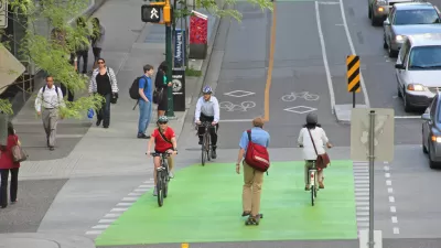
In a move bound to stir public controversy, Miami's Downtown Development Authority (DDA) intends to reduce vehicular capacity on a major street. Miami DDA will retain control of the project and is responsible for securing funding, but the State of Florida has approved and backed the measure.
From the article: "Newly christened Biscayne Green, the downtown authority's project would narrow a stretch of Biscayne Boulevard from Northeast Eighth Street south to Biscayne Boulevard Way, reduce driving lanes from eight to four or six, and shave parking spaces from 388 to 187 to create room for medians with grass, trees and walkways. It would replace a shared bicycle lane with a dedicated one and widen sidewalks. The cost for the medians was estimated at $24 million."
Certainly good news for Complete Streets advocates, but some Miami commuters may see things differently.
FULL STORY: State OKs cutting Biscayne Boulevard lanes


Chicago Had a Banner Year for Bike Infrastructure
The city built more bike lane miles in 2023 than in any previous year.

East Dallas Delays Complete Street Project
A controversial traffic calming and safety overhaul of some East Dallas streets won't be completed until 2025, but will include improved crosswalks and signals.

Op-Ed: An 18-Lane Street Is Too Complete
Rockville, Maryland has plans to create a king-sized complete street along Rockville Pike, incorporating lanes for cars, bikes, buses, and more space for landscaping. But can a street like that still serve pedestrians?

Maui's Vacation Rental Debate Turns Ugly
Verbal attacks, misinformation campaigns and fistfights plague a high-stakes debate to convert thousands of vacation rentals into long-term housing.

Planetizen Federal Action Tracker
A weekly monitor of how Trump’s orders and actions are impacting planners and planning in America.

In Urban Planning, AI Prompting Could be the New Design Thinking
Creativity has long been key to great urban design. What if we see AI as our new creative partner?

King County Supportive Housing Program Offers Hope for Unhoused Residents
The county is taking a ‘Housing First’ approach that prioritizes getting people into housing, then offering wraparound supportive services.

Researchers Use AI to Get Clearer Picture of US Housing
Analysts are using artificial intelligence to supercharge their research by allowing them to comb through data faster. Though these AI tools can be error prone, they save time and housing researchers are optimistic about the future.

Making Shared Micromobility More Inclusive
Cities and shared mobility system operators can do more to include people with disabilities in planning and operations, per a new report.
Urban Design for Planners 1: Software Tools
This six-course series explores essential urban design concepts using open source software and equips planners with the tools they need to participate fully in the urban design process.
Planning for Universal Design
Learn the tools for implementing Universal Design in planning regulations.
planning NEXT
Appalachian Highlands Housing Partners
Mpact (founded as Rail~Volution)
City of Camden Redevelopment Agency
City of Astoria
City of Portland
City of Laramie