


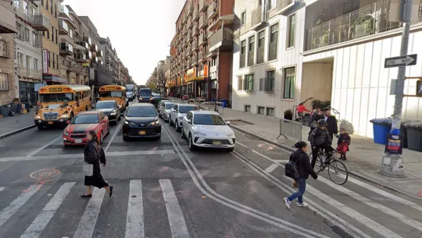
The New York City Department of Transportation is moving forward with a series of pedestrian and bike infrastructure improvements in a neighborhood built in the shadow of some of the city's most highest profile transportation infrastructure.
"DUMBO, where NYC DOT launched its public plaza program more than seven years ago, is set to get more pedestrian space as the city expands sidewalks and reworks oddly-shaped intersections beneath the Manhattan Bridge," report Stephen Miller. "The project also includes a contraflow bike lane to improve connections from DUMBO to the Manhattan Bridge, Jay Street, and Downtown Brooklyn [PDF]."
After detailing each of the components plans under consideration (e.g., neckdowns, new crosswalks, and the aforementioned contraflow bike lanes), Miller notes the local support for the proposals: "The plan has already gone before Brooklyn Community Board 2′s transportation committee. DUMBO Improvement District director of marketing and events Kristin LaBuz attended the meeting, where the plan advanced to the full board in an 11-0 vote. Though there is still much work to be done in the neighborhood,' she said, 'we’re thrilled by DOT’s responsiveness to community concerns.'"
FULL STORY: DUMBO Street Upgrades: Big Curb Expansions + Contraflow Bike Lane

Judge Halts Brooklyn Bike Lane Removal
Lawyers must prove the city was not acting “arbitrarily, capriciously, and illegally” in ordering the hasty removal.

New York City Plans Street Safety Projects as Congestion Pricing Nears
With congestion pricing projected to reduce the number of cars entering Manhattan, NYCDOT plans to repurpose street space to build more pedestrian and bike infrastructure.
NYC Streets Plan Remains Largely on Paper
For the second year in a row, the city failed to meet legally required targets for building protected bike lanes and bus lanes.

Maui's Vacation Rental Debate Turns Ugly
Verbal attacks, misinformation campaigns and fistfights plague a high-stakes debate to convert thousands of vacation rentals into long-term housing.

Planetizen Federal Action Tracker
A weekly monitor of how Trump’s orders and actions are impacting planners and planning in America.

In Urban Planning, AI Prompting Could be the New Design Thinking
Creativity has long been key to great urban design. What if we see AI as our new creative partner?

King County Supportive Housing Program Offers Hope for Unhoused Residents
The county is taking a ‘Housing First’ approach that prioritizes getting people into housing, then offering wraparound supportive services.

Researchers Use AI to Get Clearer Picture of US Housing
Analysts are using artificial intelligence to supercharge their research by allowing them to comb through data faster. Though these AI tools can be error prone, they save time and housing researchers are optimistic about the future.

Making Shared Micromobility More Inclusive
Cities and shared mobility system operators can do more to include people with disabilities in planning and operations, per a new report.
Urban Design for Planners 1: Software Tools
This six-course series explores essential urban design concepts using open source software and equips planners with the tools they need to participate fully in the urban design process.
Planning for Universal Design
Learn the tools for implementing Universal Design in planning regulations.
planning NEXT
Appalachian Highlands Housing Partners
Mpact (founded as Rail~Volution)
City of Camden Redevelopment Agency
City of Astoria
City of Portland
City of Laramie