


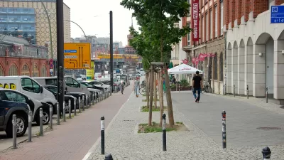
Minneapolis provides evidence of the power of robust bike infrastructure to attract additional bike riders.

"Minneapolis recorded a slight increase in bike use [in 2014], but officials saw a dramatic surge of usage on the city’s first protected bike lanes," reports Steve Brandt.
A bike count from September "found bike traffic up sharply on the Plymouth Avenue Bridge after where the city installed bike lanes separated by plastic tubes from traffic lanes."
"Bike traffic on the bridge is up 81 percent since the city installed the protected lanes during a bridge repair project in 2013. During five years when the bridge offered only shoulders or sidewalks for bikes, the city recorded an average of 350 bikes a day in its annual count. Bike traffic jumped to 720 estimated bikers in its Sept. 11, 2014, count."
Brandt provides more data from the bike count, made timely by the city's funded, but not approved, plans to spend $790,000 to build an additional 30 miles of protected bike lanes in 2015.
FULL STORY: Traffic spikes on protected bike lanes in Minneapolis

Bike Lanes Help Sidewalks, Too
A growing body of evidence shows that bike lanes put more people on bikes while also helping those people on bikes stay off sidewalks. The latest example: Honolulu.
Minneapolis Getting Bike Friendlier
The city of Minneapolis will add 30 miles of protected bike lanes to its city, especially around Downtown.
The United States' Top Large City for Biking Is...
Portland (top city in 2012)? Minneapolis (top city in 2010)? No, it's the Big Apple! New York City leaped from #7 in 2012 to the top spot this year for cities with populations of 100,000 or greater.

Maui's Vacation Rental Debate Turns Ugly
Verbal attacks, misinformation campaigns and fistfights plague a high-stakes debate to convert thousands of vacation rentals into long-term housing.

Planetizen Federal Action Tracker
A weekly monitor of how Trump’s orders and actions are impacting planners and planning in America.

San Francisco Suspends Traffic Calming Amidst Record Deaths
Citing “a challenging fiscal landscape,” the city will cease the program on the heels of 42 traffic deaths, including 24 pedestrians.

Bend, Oregon Zoning Reforms Prioritize Small-Scale Housing
The city altered its zoning code to allow multi-family housing and eliminated parking mandates citywide.

Amtrak Cutting Jobs, Funding to High-Speed Rail
The agency plans to cut 10 percent of its workforce and has confirmed it will not fund new high-speed rail projects.

LA Denies Basic Services to Unhoused Residents
The city has repeatedly failed to respond to requests for trash pickup at encampment sites, and eliminated a program that provided mobile showers and toilets.
Urban Design for Planners 1: Software Tools
This six-course series explores essential urban design concepts using open source software and equips planners with the tools they need to participate fully in the urban design process.
Planning for Universal Design
Learn the tools for implementing Universal Design in planning regulations.
planning NEXT
Appalachian Highlands Housing Partners
Mpact (founded as Rail~Volution)
City of Camden Redevelopment Agency
City of Astoria
City of Portland
City of Laramie