


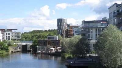
The historic Fort Mason, along with several other development projects, has helped alter the landscape of the city’s northern waterfront, according to Jim Chappell, former head of the San Francisco Planning and Urban Research Association.
While development in the aftermath of the Loma Prieta earthquake and the decimation of the double-decker Embarcadero Freeway have helped to transform San Francisco’s northern waterfront, work on the historic Fort Mason Center project has been slow going.
Jim Chappell, an architect and planner who led the San Francisco Planning and Urban Research Association (SPUR) for 15 years, describes several developments that are reshaping the area and discusses how the Fort Mason project is finally gaining ground.
“For years, it has all fallen apart when one hits Van Ness. But a brilliant new plan for the non-profit Fort Mason Center is about to change all that.”
The National Park Service owns the Fort Mason property. New development on the site includes the opening this week of the reconceived Pier 2, a 35,000-square foot, $21 million project, Chappell writes. This follows a $13 million pier substructure upgrade the park service completed.
The changes were ushered in the 2012 International Design Competition in which 20 firms were invited to submit entries for revamping Fort Mason, according to Chappell.
For years, the nonprofit foundation that runs the historic Fort Mason helped to preserve some of the cultural institutions.
“But like every other real estate venture, the world has changed for Fort Mason since September 15, 2008. The National Park Service is squeezed for resources; the non-profit tenants have always been; and Fort Mason is searching for new ways to meet its mission of supporting arts and culture in San Francisco. Thus the design competition. The competition brief called for visions to “inject cohesion, focus, and renewed energy into the campus” and “enhance Fort Mason Center’s profile as an arts and cultural destination.”
Visit Urbdezine to read more.
FULL STORY: Completing San Francisco’s Northern Waterfront

6 Ways Urban Renewal Misses the Livability Mark
Despite spending millions on urban renewal projects, municipalities often miss a common group of opportunities to make their communities more livable and walkable, according to William Adams, a San Diego-based land use attorney.
The Risks and Conflicts of Interest in San Diego's Proposed Redevelopment Scheme
Before San Diego adopts a proposal to continue redevelopment using profit-based concepts, it should pause to consider the perils, argues Murtaza H. Baxamusa, an affordable housing developer and planning professor.
Gentrification: A Perspective From a Long Time Resident
As Jacksonville's long forgotten Brooklyn neighborhood undergoes massive redevelopment, a long time resident talks about his perspective of the gentrification occurring around him.

Planetizen Federal Action Tracker
A weekly monitor of how Trump’s orders and actions are impacting planners and planning in America.

Map: Where Senate Republicans Want to Sell Your Public Lands
For public land advocates, the Senate Republicans’ proposal to sell millions of acres of public land in the West is “the biggest fight of their careers.”

Restaurant Patios Were a Pandemic Win — Why Were They so Hard to Keep?
Social distancing requirements and changes in travel patterns prompted cities to pilot new uses for street and sidewalk space. Then it got complicated.

Platform Pilsner: Vancouver Transit Agency Releases... a Beer?
TransLink will receive a portion of every sale of the four-pack.

Toronto Weighs Cheaper Transit, Parking Hikes for Major Events
Special event rates would take effect during large festivals, sports games and concerts to ‘discourage driving, manage congestion and free up space for transit.”

Berlin to Consider Car-Free Zone Larger Than Manhattan
The area bound by the 22-mile Ringbahn would still allow 12 uses of a private automobile per year per person, and several other exemptions.
Urban Design for Planners 1: Software Tools
This six-course series explores essential urban design concepts using open source software and equips planners with the tools they need to participate fully in the urban design process.
Planning for Universal Design
Learn the tools for implementing Universal Design in planning regulations.
Heyer Gruel & Associates PA
JM Goldson LLC
Custer County Colorado
City of Camden Redevelopment Agency
City of Astoria
Transportation Research & Education Center (TREC) at Portland State University
Camden Redevelopment Agency
City of Claremont
Municipality of Princeton (NJ)