


In an ongoing series, Urbanism Without Effort author Chuck Wolfe argues the importance of the overlaps, overlays and convergence points that define city life, and emphasizes the importance of reading and interpreting their everyday expression.
 In the first five short articles in a ten-part series, Wolfe uses photographs of his native Seattle to illustrate points of context, focus and catalysts for today’s urban issues and debates, all summarized in the working term, "juxtapositions". They are often in plain sight, he notes, in familiar patterns of overlap and/or interdisciplinary layers:
Look at a juxtaposition—and see confronting dilemmas, flashpoints and ripples in time—all of which are recognizable in the faces, spaces and places of everyday life.
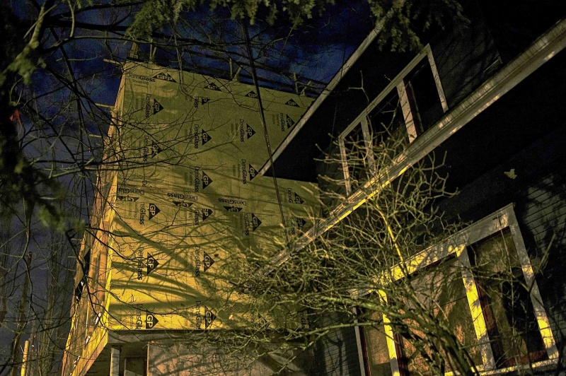
Rather than a static view, he stresses, for example, the interactivity of adjacent new and old construction, contrasting forms of light and blended land, water and natural environments. He shows visible reflections of regulatory process in human behavior. He repeats the path-crossing aspects of street corners and sit-able places.
He summarizes the importance of such urban juxtapositions in the introductory article:
These overlays align us towards discussion of sudden and gradual change, generational differences, public and private preferences, merger of cultures and business types, and mixing of land uses, transportation modes, and housing approaches. They are more than transitions, but focal points for who decides the urban agenda and who gets versus who pays. Accordingly, they drive urban politics and professional services—and we should know how to recognize and work with them...
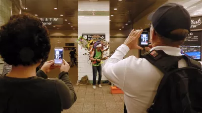
Wolfe's pragmatic tone combines with the importance of observing human behavior in the spirit of William H. Whyte, Jan Gehl and others. In the fifth article he illustrates how a corner street performer inherently knows the stages and windows and observation points of urban life—the entry points to everything from transportation modes to safety at night—and that knowledge is captured in accompanying photographs.
Why observe in the ways Wolfe suggests?
In such imagery we can predict policy debates, neighbor opposition, conflicts of parent and child in a way that can inspire dialogue, a search for consensus, or outright conflict and confusion.
For all articles in the series, click here.
FULL STORY: in the urban world, juxtapositions matter

Friday Eye Candy: The Theatricality of the Subway
A new book of photography amplifies what was already there.

New Decade Eye Candy: The Decade in Photographs
National Geographic shared a list of 15 of its best images captured during the 2010s.
The Dangers of Facial Recognition Software
Facial recognition software has the possibility to change public life completely. Countries and cities should be careful to consider the consequences of adopting the technology.

Planetizen Federal Action Tracker
A weekly monitor of how Trump’s orders and actions are impacting planners and planning in America.

Map: Where Senate Republicans Want to Sell Your Public Lands
For public land advocates, the Senate Republicans’ proposal to sell millions of acres of public land in the West is “the biggest fight of their careers.”

Restaurant Patios Were a Pandemic Win — Why Were They so Hard to Keep?
Social distancing requirements and changes in travel patterns prompted cities to pilot new uses for street and sidewalk space. Then it got complicated.

Platform Pilsner: Vancouver Transit Agency Releases... a Beer?
TransLink will receive a portion of every sale of the four-pack.

Toronto Weighs Cheaper Transit, Parking Hikes for Major Events
Special event rates would take effect during large festivals, sports games and concerts to ‘discourage driving, manage congestion and free up space for transit.”

Berlin to Consider Car-Free Zone Larger Than Manhattan
The area bound by the 22-mile Ringbahn would still allow 12 uses of a private automobile per year per person, and several other exemptions.
Urban Design for Planners 1: Software Tools
This six-course series explores essential urban design concepts using open source software and equips planners with the tools they need to participate fully in the urban design process.
Planning for Universal Design
Learn the tools for implementing Universal Design in planning regulations.
Heyer Gruel & Associates PA
JM Goldson LLC
Custer County Colorado
City of Camden Redevelopment Agency
City of Astoria
Transportation Research & Education Center (TREC) at Portland State University
Camden Redevelopment Agency
City of Claremont
Municipality of Princeton (NJ)