


An exhibit that's just opened at NYC's Center for Architecture examines the brief history of a housing type that incorporated elements of suburban housing at higher densities. Can low-rise high-density houding provide a model for affordable infill?
"'Low Rise High Density' is the brainchild of curator Karen Kubey, executive director of the IPA, who began her research on the topic while a student at Columbia University’s GSAPP," writes Sabrina Wirth. The exhibit, "examines the history of a typology that sprung up 40 years ago, when the need for space and better living conditions led to alternatives to high-rise public housing."
"Modeled a bit after suburban homes, these low-rise high-density buildings reached prominence in the 1970s," explains Wirth. "This type of housing serves two functions: 1) to intensify land use as urban growth escalates by providing higher density; and 2) to improve living conditions by using suburban housing characteristics such as more open space, more light, and a closer connection to the ground."
"Through a curated set of photographs, architectural drawings, and original oral histories, 'Low Rise High Density' brings into context a housing model that lacks significant contemporary scholarship."
FULL STORY: Goodbye, Micro-Apartments: ‘Low Rise High Density’ Presents An Alternative Housing Solution

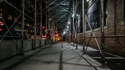
A Closer Look Under the Sidewalk Scaffolding of New York City
A common part of the urban landscape, scaffolds are mostly ignored or detested. But these in-between spaces can also take on a life of their own.
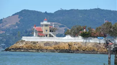
Developer's Ballot Box Planning Would Allow Suburban Development at Ferry Terminal
A June 7 ballot measure in Richmond, California would permit 59 single family homes to be built on a 5-acre bayfront lot within walking distance to a future ferry landing for San Francisco service. The site is zoned for high-density housing.

NIMBYs at Center of California's Housing Shortage
Sacramento Bee's political columnist, Dan Walters, writes that NIMBYs are among the main reasons for the state's chronic housing crisis, and one of their main tools is the California Environmental Quality Act, which must be reformed by politicians.

Planetizen Federal Action Tracker
A weekly monitor of how Trump’s orders and actions are impacting planners and planning in America.

Map: Where Senate Republicans Want to Sell Your Public Lands
For public land advocates, the Senate Republicans’ proposal to sell millions of acres of public land in the West is “the biggest fight of their careers.”

Restaurant Patios Were a Pandemic Win — Why Were They so Hard to Keep?
Social distancing requirements and changes in travel patterns prompted cities to pilot new uses for street and sidewalk space. Then it got complicated.

Platform Pilsner: Vancouver Transit Agency Releases... a Beer?
TransLink will receive a portion of every sale of the four-pack.

Toronto Weighs Cheaper Transit, Parking Hikes for Major Events
Special event rates would take effect during large festivals, sports games and concerts to ‘discourage driving, manage congestion and free up space for transit.”

Berlin to Consider Car-Free Zone Larger Than Manhattan
The area bound by the 22-mile Ringbahn would still allow 12 uses of a private automobile per year per person, and several other exemptions.
Urban Design for Planners 1: Software Tools
This six-course series explores essential urban design concepts using open source software and equips planners with the tools they need to participate fully in the urban design process.
Planning for Universal Design
Learn the tools for implementing Universal Design in planning regulations.
Heyer Gruel & Associates PA
JM Goldson LLC
Custer County Colorado
City of Camden Redevelopment Agency
City of Astoria
Transportation Research & Education Center (TREC) at Portland State University
Camden Redevelopment Agency
City of Claremont
Municipality of Princeton (NJ)