


Mark Wilson looks at the NY MTA's plan to install 90 touch-screen kiosks at subway stations around the city beginning this year. The innovative kiosks will offer rider information, interactive maps, and will even be able to run third-party apps.
Developed by Control Group, designers of a radical vision to remake New York's payphones, "[e]ach kiosk is a 47-inch touch screen, encapsulated in rugged stainless steel, with an operational temperature up to 200 degrees (which is more than durable enough to handle 120-degree summer days in the subway). They’ll be placed, mostly in pairs, outside pay areas, inside mezzanines and even right on train platforms," says Wilson.
"At launch, the screens will feature all sorts of content, like delays, outages, and, of course, ads (which bring in $100 million in revenue for the MTA each year, but mostly in paper signage). Yet its most powerful interaction for many will likely be its map, which features a one-tap navigation system. Seriously. You look at the map, you tap your intended destination, and the map will draw your route, including any transfers along the way. It’s an interface that puts Google Maps to shame."
"At the same time," Wilson adds, "the system’s screens could be the least interesting part of this project. The kiosks will be fitted with extra modules--video cameras, mics, and Wi-Fi--to open up a whole secondary layer of data collection and interface."
FULL STORY: NYC Subways Deploy A Touch-Screen Network, Complete With Apps

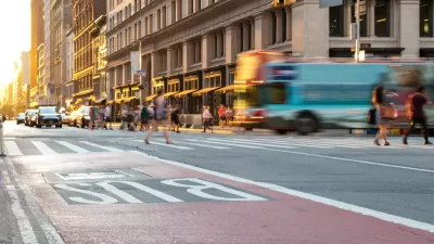
New York Officials Back Down on Bus Lane Plans
Proposed bus improvements in the Bronx are the latest casualty of opposition.

Fancy New Subway Cars Join the New York Subway System
New York has been planning on adding these new subway cars for years, finally achieving their goal in March 2023. More than a thousand of the new R211 trains will be running in New York within two years if all goes according to plan.

Changes to Local Service in the Bronx Benefit Bus Speeds, Ridership
Another example of how improving bus service design can benefit transit riders and transit systems emerges in New York City. More such local system redesigns are on the way soon in the Big Apple.

Planetizen Federal Action Tracker
A weekly monitor of how Trump’s orders and actions are impacting planners and planning in America.

Map: Where Senate Republicans Want to Sell Your Public Lands
For public land advocates, the Senate Republicans’ proposal to sell millions of acres of public land in the West is “the biggest fight of their careers.”

Restaurant Patios Were a Pandemic Win — Why Were They so Hard to Keep?
Social distancing requirements and changes in travel patterns prompted cities to pilot new uses for street and sidewalk space. Then it got complicated.

Platform Pilsner: Vancouver Transit Agency Releases... a Beer?
TransLink will receive a portion of every sale of the four-pack.

Toronto Weighs Cheaper Transit, Parking Hikes for Major Events
Special event rates would take effect during large festivals, sports games and concerts to ‘discourage driving, manage congestion and free up space for transit.”

Berlin to Consider Car-Free Zone Larger Than Manhattan
The area bound by the 22-mile Ringbahn would still allow 12 uses of a private automobile per year per person, and several other exemptions.
Urban Design for Planners 1: Software Tools
This six-course series explores essential urban design concepts using open source software and equips planners with the tools they need to participate fully in the urban design process.
Planning for Universal Design
Learn the tools for implementing Universal Design in planning regulations.
Heyer Gruel & Associates PA
JM Goldson LLC
Custer County Colorado
City of Camden Redevelopment Agency
City of Astoria
Transportation Research & Education Center (TREC) at Portland State University
Camden Redevelopment Agency
City of Claremont
Municipality of Princeton (NJ)