


Along a nondescript street in Chicago's gritty West Side, a 1.5-mile stretch of a "historic, industrial artery" has been given a futuristic makeover as the greenest street in the country, and perhaps the world, reports Lori Rotenberk.
In the shadow of the soon-to-be-closed Fisk coal-fired power plant, Chicago officials recently unveiled a reborn stretch of Cermak Road - which has already become a model for streetscape sustainability. "The unlikely marriage of sustainability and this gritty corridor isn't
accidental," says Rotenberk. "The Chicago Department of Transportation has spent two years
and $16 million on this stretch of Cermak, which serves as the southern
gateway to the city's Pilsen neighborhood."
"David Leopold, project manager for the CDOT, says he took everything
that would make a building LEED platinum and built it into the
streetscape. Improvements range from solar-paneled bus stops to native
plants and pavement that sucks up rainwater. Other cities are studying
the project as a blueprint for change."
"CDOT engineers at first planned to give Cermak the usual
not-so-eco-groovy upgrade," explains Rotenberk. "Leopold, however, saw the raw beauty - and
how good it would look in green. Armed with TIF (Tax Increment Financing)
funds and grant money, CDOT set to work, incorporating what Leopold
believes is the greatest number of sustainable elements ever to go into a
single stretch of road."
FULL STORY: The greenest mile: Chicago pushes the limits on sustainable streets

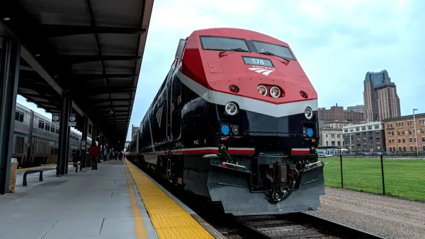
Amtrak’s Borealis Exceeds First Year Ridership Expectations
205,800 passengers have boarded the St. Paul to Chicago line, well above initial MDOT projections.

Chicago Judge Orders Thousands of Accessible Ped Signals
Only 3% of the city's crossing signals are currently accessible to blind pedestrians.
Chicago Transit: $770M Shortfall, 40% Service Cuts Loom
Despite dire warnings from transit officials, the Illinois General Assembly ended its legislative session without a solution.

Planetizen Federal Action Tracker
A weekly monitor of how Trump’s orders and actions are impacting planners and planning in America.

Map: Where Senate Republicans Want to Sell Your Public Lands
For public land advocates, the Senate Republicans’ proposal to sell millions of acres of public land in the West is “the biggest fight of their careers.”

Restaurant Patios Were a Pandemic Win — Why Were They so Hard to Keep?
Social distancing requirements and changes in travel patterns prompted cities to pilot new uses for street and sidewalk space. Then it got complicated.

Albuquerque Route 66 Motels Become Affordable Housing
A $4 million city fund is incentivizing developers to breathe new life into derelict midcentury motels.

DC Area County Eliminates Bus Fares
Montgomery County joins a growing trend of making transit free.

Platform Pilsner: Vancouver Transit Agency Releases... a Beer?
TransLink will receive a portion of every sale of the four-pack.
Urban Design for Planners 1: Software Tools
This six-course series explores essential urban design concepts using open source software and equips planners with the tools they need to participate fully in the urban design process.
Planning for Universal Design
Learn the tools for implementing Universal Design in planning regulations.
Heyer Gruel & Associates PA
JM Goldson LLC
Custer County Colorado
City of Camden Redevelopment Agency
City of Astoria
Transportation Research & Education Center (TREC) at Portland State University
Camden Redevelopment Agency
City of Claremont
Municipality of Princeton (NJ)