


Google is big business in Mountain View, but it's located in a cul-de-sac business park two miles from the city's transit center. "Personal rapid transit" may be the answer to solving the company's commuting challenges.
Like the rest of the Bay Area, Mountain View is investing heavily in public transit, as evidenced by the fact that the downtown transit center is a hub for both Caltrain and the San Jose light-rail line. But the North Bayshore area – locale for the Google headquarters as well as offices for such companies as LinkedIn, Intuit, and even Microsoft – is two long miles away up Shoreline Boulevard, on the wrong side of a constrained overpass that spans Highway 101 and boxed in by the San Francisco Bay and the former Moffett Field Naval Air Station.
At a transportation workshop last Friday, four experts from around the country provided ideas for Mountain View and Google to consider as the city embarks upon the North Bayshore Precise Plan. The ideas ranged from the obvious – charging employees for parking – to the far-out, such as a "personal rapid transit" system that would whisk employees to and fro within the North Bayshore area, to and from the transit center, and possibly to other destinations as well.
Thanks to Bill Fulton
FULL STORY: Google and Mountain View May Pursue "Personal Rapid Transit" To Solve Commute Congestion

Taking the 'Mass' Out of Mass Transit
Is the isolation of personal rapid transit truly viable for mass transit?

Why a Failed ‘Smart City’ Is Still Relevant
A Google-backed proposal to turn an underused section of Toronto waterfront into a tech hub holds relevant lessons about privacy and data.
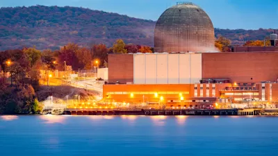
Google Inks Nuclear Power Deal
Tech giants are seeking out renewable energy to fuel power-hungry data centers and AI applications.

Planetizen Federal Action Tracker
A weekly monitor of how Trump’s orders and actions are impacting planners and planning in America.

Map: Where Senate Republicans Want to Sell Your Public Lands
For public land advocates, the Senate Republicans’ proposal to sell millions of acres of public land in the West is “the biggest fight of their careers.”

Restaurant Patios Were a Pandemic Win — Why Were They so Hard to Keep?
Social distancing requirements and changes in travel patterns prompted cities to pilot new uses for street and sidewalk space. Then it got complicated.

Platform Pilsner: Vancouver Transit Agency Releases... a Beer?
TransLink will receive a portion of every sale of the four-pack.

Toronto Weighs Cheaper Transit, Parking Hikes for Major Events
Special event rates would take effect during large festivals, sports games and concerts to ‘discourage driving, manage congestion and free up space for transit.”

Berlin to Consider Car-Free Zone Larger Than Manhattan
The area bound by the 22-mile Ringbahn would still allow 12 uses of a private automobile per year per person, and several other exemptions.
Urban Design for Planners 1: Software Tools
This six-course series explores essential urban design concepts using open source software and equips planners with the tools they need to participate fully in the urban design process.
Planning for Universal Design
Learn the tools for implementing Universal Design in planning regulations.
Heyer Gruel & Associates PA
JM Goldson LLC
Custer County Colorado
City of Camden Redevelopment Agency
City of Astoria
Transportation Research & Education Center (TREC) at Portland State University
Camden Redevelopment Agency
City of Claremont
Municipality of Princeton (NJ)