


Used by Condoleezza Rice and George W. Bush to define a key difference between "free" and "fear" states, historian Jeffrey Wasserstrom looks to the global public uprisings of 2011 to prove the validity of the Town Square Test.
Directly tying the political state of a country to the use of public space, "At the heart of the Town Square Test is the notion that the difference between living in a "free" state and living in a "fear" state is clear and comes down to whether a person can go to the town square and "express his or her views without fear of arrest, imprisonment, or physical harm."
Wasserstrom asserts that Rice encouraged the U.S. Government to use the test to guide foreign policy, identifying opportunities to turn "fear" states into "free" ones.
"News stories from 2011 provided plenty of fresh evidence that people in many parts of the world thirst for a greater degree of freedom and often are willing to take great risks in pursuit of this goal, but in many other ways, the year's events challenged, rather than reinforced, the Town Square Test worldview."
FULL STORY: OWS, Egypt Expose Limits of Town Square Test

Occupy Democracy in Parliament Square
A recent protest movement to reuse London’s Parliament Square as a space for political discourse has been met with oppressive policing.
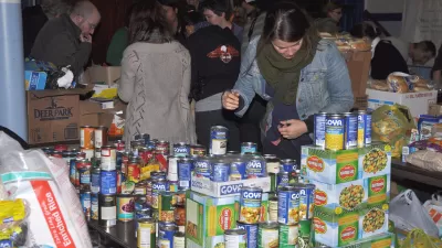
Occupy Sandy: A New Model for Disaster Response?
One of the odd twists of the Sandy aftermath is the repurposing of the Occupy Wall Street apparatus as one of the most effective aid groups operating in New York. Could their work serve as a model for locally-based disaster recovery?
One Year Later, Assessing Occupy Wall Street's Effect on Space
On the one-year anniversary of the beginning of Occupy Wall Street, Richard Sennett looks at the movement's legacy with regards to rethinking public space.

Planetizen Federal Action Tracker
A weekly monitor of how Trump’s orders and actions are impacting planners and planning in America.

Map: Where Senate Republicans Want to Sell Your Public Lands
For public land advocates, the Senate Republicans’ proposal to sell millions of acres of public land in the West is “the biggest fight of their careers.”

Restaurant Patios Were a Pandemic Win — Why Were They so Hard to Keep?
Social distancing requirements and changes in travel patterns prompted cities to pilot new uses for street and sidewalk space. Then it got complicated.

Platform Pilsner: Vancouver Transit Agency Releases... a Beer?
TransLink will receive a portion of every sale of the four-pack.

Toronto Weighs Cheaper Transit, Parking Hikes for Major Events
Special event rates would take effect during large festivals, sports games and concerts to ‘discourage driving, manage congestion and free up space for transit.”

Berlin to Consider Car-Free Zone Larger Than Manhattan
The area bound by the 22-mile Ringbahn would still allow 12 uses of a private automobile per year per person, and several other exemptions.
Urban Design for Planners 1: Software Tools
This six-course series explores essential urban design concepts using open source software and equips planners with the tools they need to participate fully in the urban design process.
Planning for Universal Design
Learn the tools for implementing Universal Design in planning regulations.
Heyer Gruel & Associates PA
JM Goldson LLC
Custer County Colorado
City of Camden Redevelopment Agency
City of Astoria
Transportation Research & Education Center (TREC) at Portland State University
Camden Redevelopment Agency
City of Claremont
Municipality of Princeton (NJ)