


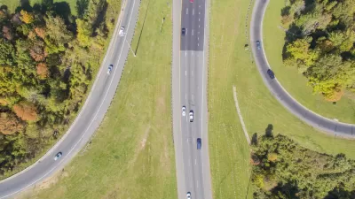
Researchers look at the largely suburban South Bay area of Los Angeles to offer ways to retrofit auto-oriented suburbs for more pedestrian travel.
"Researchers have spilled much ink debating the feasibility of alternatives to car travel, but have focused less on how suburbs built for the car might be transformed to accommodate other modes. Seven years ago, communities in the South Bay area of Los Angeles County decided to focus on this question. They found that walking is the gateway mode for alternative transportation," write an impressive array of authors, including Marlon G. Boarnet, Kenneth Joh, Walter Siembab, William Fulton, and Mai Thi Nguyen.
"While traditional urban design elements such as inwardly focused street geometry may encourage walking, our results suggest that a more critical factor is the concentration of business activity in a compact commercial center. The tricky part is that the business concentration needed to encourage walking appears to be larger than most neighborhood residential populations can support. Given that, suburban regions should focus both on fostering pedestrian centers and on knitting those centers together with transportation networks, though such networks need not accommodate only cars. We suggest both a land use approach and a mobility approach, and coordination between the two."
FULL STORY: Retrofitting the Suburbs to Increase Walking

Obesity Tied to Suburban Life
London-based study ties obesity to sprawl and finds that suburbs have a bigger obesity problem than rural areas.
Transit-Walkability Collaborative Established
The new Transit-Walkability Collaborative works to create safe, healthy, equitable, and sustainable communities by harnessing the synergy between walkability and quality public transit service.
City vs. Suburb Battle Reignites
There's a new volley in the long-running battle between cities and suburbs. In his new book "The Human City," urban scholar Joel Kotkin contends that cities and their planners have lost sight of the residents who matter most: families.

Planetizen Federal Action Tracker
A weekly monitor of how Trump’s orders and actions are impacting planners and planning in America.

Restaurant Patios Were a Pandemic Win — Why Were They so Hard to Keep?
Social distancing requirements and changes in travel patterns prompted cities to pilot new uses for street and sidewalk space. Then it got complicated.

Map: Where Senate Republicans Want to Sell Your Public Lands
For public land advocates, the Senate Republicans’ proposal to sell millions of acres of public land in the West is “the biggest fight of their careers.”

Maui's Vacation Rental Debate Turns Ugly
Verbal attacks, misinformation campaigns and fistfights plague a high-stakes debate to convert thousands of vacation rentals into long-term housing.

San Francisco Suspends Traffic Calming Amidst Record Deaths
Citing “a challenging fiscal landscape,” the city will cease the program on the heels of 42 traffic deaths, including 24 pedestrians.

California Homeless Arrests, Citations Spike After Ruling
An investigation reveals that anti-homeless actions increased up to 500% after Grants Pass v. Johnson — even in cities claiming no policy change.
Urban Design for Planners 1: Software Tools
This six-course series explores essential urban design concepts using open source software and equips planners with the tools they need to participate fully in the urban design process.
Planning for Universal Design
Learn the tools for implementing Universal Design in planning regulations.
Heyer Gruel & Associates PA
JM Goldson LLC
Custer County Colorado
City of Camden Redevelopment Agency
City of Astoria
Transportation Research & Education Center (TREC) at Portland State University
Camden Redevelopment Agency
City of Claremont
Municipality of Princeton (NJ)