


To encourage train ridership, Caltrans and Metrolink have teamed up to display train times on electronic signs along two oft-congested Southern California freeways.
"'For travel between Orange County and downtown Los Angeles' Union Station, trains are often faster than freeways,' said Malcolm Dougherty, acting Caltrans Director. 'We want to give commuters real-time information to help them get to their destination quicker.'
Caltrans provides the freeway travel time information using data collected from its vehicle detector stations throughout the freeway system while Metrolink offers train travel times, including train departure and trip duration information.
Along the 87-mile Orange County line, an average of 7,744 weekday riders traveled on Metrolink's 24 trains last year between April and June, according to Metrolink figures."
FULL STORY: Stuck on freeway? Signs show train times


Southern California Rail Service Resumes After Landslide
The corridor has been closed multiple times in the past year as erosion and landslides put coastal rail infrastructure in jeopardy.
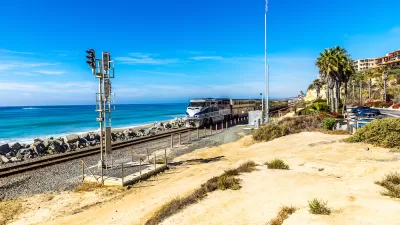
Storms Sever California Rail Line—Again
The coast-hugging rail corridor linking Los Angeles and San Diego faces an uncertain future as mudslides once again force part of the line to close.

State Leaders Warn of Risks to Southern California Rail Corridor
Coastal erosion and rising sea levels threaten one of the nation’s most scenic—and strategically important—rail corridors.

Planetizen Federal Action Tracker
A weekly monitor of how Trump’s orders and actions are impacting planners and planning in America.

Restaurant Patios Were a Pandemic Win — Why Were They so Hard to Keep?
Social distancing requirements and changes in travel patterns prompted cities to pilot new uses for street and sidewalk space. Then it got complicated.

Map: Where Senate Republicans Want to Sell Your Public Lands
For public land advocates, the Senate Republicans’ proposal to sell millions of acres of public land in the West is “the biggest fight of their careers.”

Maui's Vacation Rental Debate Turns Ugly
Verbal attacks, misinformation campaigns and fistfights plague a high-stakes debate to convert thousands of vacation rentals into long-term housing.

San Francisco Suspends Traffic Calming Amidst Record Deaths
Citing “a challenging fiscal landscape,” the city will cease the program on the heels of 42 traffic deaths, including 24 pedestrians.

California Homeless Arrests, Citations Spike After Ruling
An investigation reveals that anti-homeless actions increased up to 500% after Grants Pass v. Johnson — even in cities claiming no policy change.
Urban Design for Planners 1: Software Tools
This six-course series explores essential urban design concepts using open source software and equips planners with the tools they need to participate fully in the urban design process.
Planning for Universal Design
Learn the tools for implementing Universal Design in planning regulations.
Heyer Gruel & Associates PA
JM Goldson LLC
Custer County Colorado
City of Camden Redevelopment Agency
City of Astoria
Transportation Research & Education Center (TREC) at Portland State University
Camden Redevelopment Agency
City of Claremont
Municipality of Princeton (NJ)