


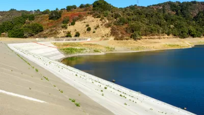
The Santa Clara Water District is buying back a piece of land of very little value from a developer who intended it to be part of a "new town" of 100,000 residents. From dream to discard, here is the story.
In the hills east of Highway 101 near Morgan Hill, California lies over a thousand acres bought in the early 1960s by developer Castle & Cooke. It was the era of rampant development in San Jose, and the developer planned a "massive 'New Town' with stores, schools and 100,000 residents." But the tide turned against the quickly spreading city, and the rising environmental movement killed development in the hills. Castle & Cooke sued the city and lost.
Today, reports Paul Rogers, the Santa Clara Valley Water District is buying the land, including a pretty much useless section that is entirely underwater:
"The agency didn't set out to buy underwater land, said Ann Draper, acting chief operating officer of the water district. It needs the dry parcels to comply with state and federal permits, she said, that require the agency to protect the habitat of endangered species that are disturbed when water district crews perform flood control work in hundreds of miles of streams every year across Santa Clara County."
FULL STORY: Underwater mortgage? Water district to buy real estate that is literally under water

Desalination and Water Recycling Needed to Increase Bay Area Water Supply
In an ongoing drought exacerbated by climate change, the Bay Area needs to look toward two technologies to secure adequate drinking water supply: desalination and wastewater recycling, according to an analysis by the San Francisco Examiner.
California Coastal Commission Rejects $1.4 Billion Desalination Project
The unanimous decision by the Coastal Commission on May 12 might have dealt a fatal blow to the costly seawater desalination project proposed for Huntington Beach, but it was not 'a referendum on the future of desalination in California.'
Value Capture Replaces Congestion Pricing as Governor Cuomo's Subway Funding Fix
Gov. Andrew Cuomo (D-N.Y.) appears to be backing away from a controversial plan to toll midtown Manhattan but shows no reservations about embracing land value capture, which some regard as a "taking" by taxing land proximate to subway stations.

Planetizen Federal Action Tracker
A weekly monitor of how Trump’s orders and actions are impacting planners and planning in America.

Map: Where Senate Republicans Want to Sell Your Public Lands
For public land advocates, the Senate Republicans’ proposal to sell millions of acres of public land in the West is “the biggest fight of their careers.”

Restaurant Patios Were a Pandemic Win — Why Were They so Hard to Keep?
Social distancing requirements and changes in travel patterns prompted cities to pilot new uses for street and sidewalk space. Then it got complicated.

Platform Pilsner: Vancouver Transit Agency Releases... a Beer?
TransLink will receive a portion of every sale of the four-pack.

Toronto Weighs Cheaper Transit, Parking Hikes for Major Events
Special event rates would take effect during large festivals, sports games and concerts to ‘discourage driving, manage congestion and free up space for transit.”

Berlin to Consider Car-Free Zone Larger Than Manhattan
The area bound by the 22-mile Ringbahn would still allow 12 uses of a private automobile per year per person, and several other exemptions.
Urban Design for Planners 1: Software Tools
This six-course series explores essential urban design concepts using open source software and equips planners with the tools they need to participate fully in the urban design process.
Planning for Universal Design
Learn the tools for implementing Universal Design in planning regulations.
Heyer Gruel & Associates PA
JM Goldson LLC
Custer County Colorado
City of Camden Redevelopment Agency
City of Astoria
Transportation Research & Education Center (TREC) at Portland State University
Camden Redevelopment Agency
City of Claremont
Municipality of Princeton (NJ)