


Climate change and sea level rise are expected to increase the amount of major storm events worldwide. For coastal parts of New York City, the effects could be catastrophic. The city is trying to plan now for the storms to come.
WNYC takes a detailed look at how extreme weather events are likely to affect New York City, and what the government is doing to mitigate those impacts.
"Mayor Michael Bloomberg's Panel on Climate Change said an increase in the number of such devastating storms is "extremely likely."
John Nolon, a Pace University law professor with an expertise in sustainability law, said city officials have done a good job of at least describing the problem. "A lot of New York City is less than 16 feet above mean sea level," he said. "Lower Manhattan, some points are five feet above sea level. These areas are vulnerable and New York City knows it. Compared to other cities, which are only now beginning to wake up to this issue, I think New York City is much further ahead."
But what to do?
David Bragdon, Director of the Mayor's Office of Long-Term Planning & Sustainability, is charged with preparing for the dangers of climate change. He said the city is taking precautions like raising the pumps at a wastewater treatment plant in the Rockaways and building the Willets Point development in Queens on six feet of landfill. The goal is to manage the risk from 100-year storms – one of the most severe. The mayor's report says by the end of this century, 100-year storms could start arriving every 15 to 35 years."
FULL STORY: Sea Level Rise Could Turn New York Into Venice, Experts Warn


Battery Park Resilience Project Breaks Ground
By 2027, the shoreline will be elevated by 5 feet to prevent flooding from future storm surges.
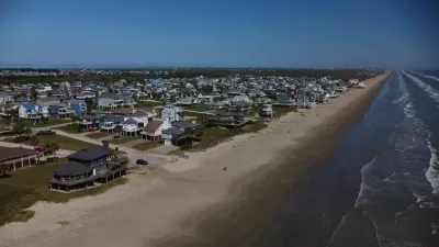
Looking for a Beach House? Check Your Risk First.
A new report from the insurance industry names the historic town of Galveston, Texas as the riskiest place to buy a beach house in the United States.
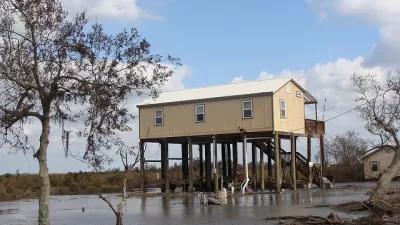
FEMA Flood Mitigation Initiative Will Pay Homeowners To Move
The Swift Current grant program will distribute $60 million to homeowners in high-risk counties to help pay for flood mitigation measures or relocation.

Planetizen Federal Action Tracker
A weekly monitor of how Trump’s orders and actions are impacting planners and planning in America.

Restaurant Patios Were a Pandemic Win — Why Were They so Hard to Keep?
Social distancing requirements and changes in travel patterns prompted cities to pilot new uses for street and sidewalk space. Then it got complicated.

Map: Where Senate Republicans Want to Sell Your Public Lands
For public land advocates, the Senate Republicans’ proposal to sell millions of acres of public land in the West is “the biggest fight of their careers.”

Orange County, Florida Adopts Largest US “Sprawl Repair” Code
The ‘Orange Code’ seeks to rectify decades of sprawl-inducing, car-oriented development.

Maui's Vacation Rental Debate Turns Ugly
Verbal attacks, misinformation campaigns and fistfights plague a high-stakes debate to convert thousands of vacation rentals into long-term housing.

San Francisco Suspends Traffic Calming Amidst Record Deaths
Citing “a challenging fiscal landscape,” the city will cease the program on the heels of 42 traffic deaths, including 24 pedestrians.
Urban Design for Planners 1: Software Tools
This six-course series explores essential urban design concepts using open source software and equips planners with the tools they need to participate fully in the urban design process.
Planning for Universal Design
Learn the tools for implementing Universal Design in planning regulations.
Heyer Gruel & Associates PA
JM Goldson LLC
Custer County Colorado
City of Camden Redevelopment Agency
City of Astoria
Transportation Research & Education Center (TREC) at Portland State University
Camden Redevelopment Agency
City of Claremont
Municipality of Princeton (NJ)