


In this reflection on the new book "Los Angeles in Maps", James Rojas wonders what shape the city will take in the near and far future.
"The book's historical and archival maps of Los Angeles give a powerful account of the city's growth and development, highlighting how topography, policies, resources and infrastructure systems shaped L.A.. The maps start with the Spanish ranches and L.A.'s early street grid, and move from there to early rail maps that predict the region's development patterns. Small towns surrounded by farms were located along rail lines. Oil wells and movie studios grew around those towns and shaped how we used our resources. All this helped create our messy, vibrant urban sprawl.
Today, it is impossible for any single policy, resource, or system to reshape L.A. the way those early systems did because we are just too massive in scale. We also no longer have plentiful tracts of empty land, nor the capital to build major projects. (Or, maybe we just built the wrong major projects, like massive housing on former orange groves at the urban edge?)."
Rojas argues that while infrastructure largely guided the form of the city throughout its history, ethnic and cultural diversity are playing a bigger role today in reshaping the city.
FULL STORY: Los Angeles in Maps: What's Next?


Parks and Gardens as Spaces to Celebrate Lunar New Year
Parks and gardens serve as communal spaces that bring people together. As such, there are good reasons for them to host events and activities that celebrate Lunar New Year, an important festival deeply rooted in Asian cultures.
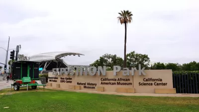
The Importance of LA's Exposition Park
Centrally located in Los Angeles, Exposition Park is a 160-acre urban park that is home to key recreational, cultural, educational, and athletic institutions and facilities. Learn more about the park from its general manager Andrea Ambriz.
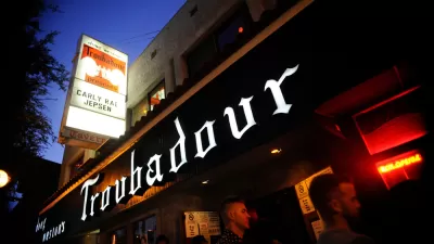
Independent Music Venues Face a Tough Road Ahead
Where have all the venues gone?

Planetizen Federal Action Tracker
A weekly monitor of how Trump’s orders and actions are impacting planners and planning in America.

Map: Where Senate Republicans Want to Sell Your Public Lands
For public land advocates, the Senate Republicans’ proposal to sell millions of acres of public land in the West is “the biggest fight of their careers.”

Restaurant Patios Were a Pandemic Win — Why Were They so Hard to Keep?
Social distancing requirements and changes in travel patterns prompted cities to pilot new uses for street and sidewalk space. Then it got complicated.

Platform Pilsner: Vancouver Transit Agency Releases... a Beer?
TransLink will receive a portion of every sale of the four-pack.

Toronto Weighs Cheaper Transit, Parking Hikes for Major Events
Special event rates would take effect during large festivals, sports games and concerts to ‘discourage driving, manage congestion and free up space for transit.”

Berlin to Consider Car-Free Zone Larger Than Manhattan
The area bound by the 22-mile Ringbahn would still allow 12 uses of a private automobile per year per person, and several other exemptions.
Urban Design for Planners 1: Software Tools
This six-course series explores essential urban design concepts using open source software and equips planners with the tools they need to participate fully in the urban design process.
Planning for Universal Design
Learn the tools for implementing Universal Design in planning regulations.
Heyer Gruel & Associates PA
JM Goldson LLC
Custer County Colorado
City of Camden Redevelopment Agency
City of Astoria
Transportation Research & Education Center (TREC) at Portland State University
Camden Redevelopment Agency
City of Claremont
Municipality of Princeton (NJ)