


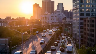
Through a survey of New York City taxis with GPS tracking devices, the city has created a database of speeds and routes that gives them a clear picture of the state of traffic in the city.
"Traffic in Manhattan has a rhythm all its own, and, according to a new study by the city, it is not quite the constant gridlock that it seems.
Using data from the GPS devices in all New York City cabs, officials tracked the routes of tens of millions of taxi trips over the past two years. The result: a database of speeds and travel routes that can be broken down by minute, month and neighborhood.
'It's like an M.R.I.,' said Bruce Schaller, a deputy transportation commissioner who supervised the city's study."
The data offers officials a look at where traffic problems have been occurring, and when they're likely to occur. Transportation officials are already using the data to tweak traffic along one of the city main arteries, according to this piece from The New York Times.
FULL STORY: Gridlock May Not Be Constant, but Slow Going Is Here to Stay


Judge Extends NYC Congestion Pricing Through at Least June 9
A federal judge halted the Trump administration’s effort to kill the program, which remains in limbo as a lawsuit filed by the MTA moves forward.

NYC Congestion Pricing Continues to Show Positive Results
While the Trump administration attempts to revoke the program’s federal approval, congestion pricing continues to reduce traffic, speed up bus travel times, and improve air quality in Manhattan.
USDOT Threatens to Pull New York Highway Funding
The Trump administration wants the state to kill New York City’s congestion pricing program despite its demonstrated success.

Planetizen Federal Action Tracker
A weekly monitor of how Trump’s orders and actions are impacting planners and planning in America.

Maui's Vacation Rental Debate Turns Ugly
Verbal attacks, misinformation campaigns and fistfights plague a high-stakes debate to convert thousands of vacation rentals into long-term housing.

San Francisco Suspends Traffic Calming Amidst Record Deaths
Citing “a challenging fiscal landscape,” the city will cease the program on the heels of 42 traffic deaths, including 24 pedestrians.

Amtrak Rolls Out New Orleans to Alabama “Mardi Gras” Train
The new service will operate morning and evening departures between Mobile and New Orleans.

The Subversive Car-Free Guide to Trump's Great American Road Trip
Car-free ways to access Chicagoland’s best tourist attractions.

San Antonio and Austin are Fusing Into one Massive Megaregion
The region spanning the two central Texas cities is growing fast, posing challenges for local infrastructure and water supplies.
Urban Design for Planners 1: Software Tools
This six-course series explores essential urban design concepts using open source software and equips planners with the tools they need to participate fully in the urban design process.
Planning for Universal Design
Learn the tools for implementing Universal Design in planning regulations.
Heyer Gruel & Associates PA
JM Goldson LLC
Custer County Colorado
City of Camden Redevelopment Agency
City of Astoria
Transportation Research & Education Center (TREC) at Portland State University
Jefferson Parish Government
Camden Redevelopment Agency
City of Claremont