


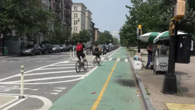
Brooklyn residents have built a makeshift detour sign in an attempt to redirect drivers away from their street. A new bike lane was implemented in the fall that has removed stop signs and, according to residents, made their street unsafe.
"A new two-way bike lane was installed on Kent Avenue this past fall, accompanied by "No Stopping" signs, which have caused an uproar among community residents and businesses who lost a number of free curbside parking spaces and say the safety of their children is now at risk."
"'You cannot even drop off your kids. Buses are getting tickets. The deliveryman doesn't want to deliver, even my grocery delivery guy doesn't want to come,' says Kent Avenue resident Leo Moskowitz."
"'It's like living on a highway. It's less safe. Trucks are zooming like crazy. Kids can't play outside. People are very upset and talking about moving away,' he says."
"Several published reports have suggested the Kent Avenue dispute is rooted in a cultural clash between the Hasidic community that is dominant in the neighborhood and the 'hipsters' that dominate the bike lane, but Moskowitz says 'this is not a Hasidic fight, it's a community fight.'"
FULL STORY: Brooklyn Bike Lane Controversy Continues

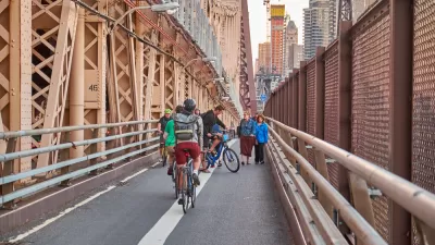
Bike-Centered Brooklyn Bridge Redo Under Consideration
City officials in New York are discussing the possibility of converting a car traffic lane on the Brooklyn Bridge for use by people on bikes.
Study: Bike Lanes Raise Property Values in Brooklyn
New bike lanes in the Brooklyn neighborhood of Bushwick started raising property values within a year.
Got Protected Bike Lanes?
While Angie Schmitt doesn't ask this question in her article on the movement behind these lanes, she writes that cities without them "are being left behind". They're popular because they effectively address the #1 reason for not riding: safety

Planetizen Federal Action Tracker
A weekly monitor of how Trump’s orders and actions are impacting planners and planning in America.

Map: Where Senate Republicans Want to Sell Your Public Lands
For public land advocates, the Senate Republicans’ proposal to sell millions of acres of public land in the West is “the biggest fight of their careers.”

Restaurant Patios Were a Pandemic Win — Why Were They so Hard to Keep?
Social distancing requirements and changes in travel patterns prompted cities to pilot new uses for street and sidewalk space. Then it got complicated.

Platform Pilsner: Vancouver Transit Agency Releases... a Beer?
TransLink will receive a portion of every sale of the four-pack.

Toronto Weighs Cheaper Transit, Parking Hikes for Major Events
Special event rates would take effect during large festivals, sports games and concerts to ‘discourage driving, manage congestion and free up space for transit.”

Berlin to Consider Car-Free Zone Larger Than Manhattan
The area bound by the 22-mile Ringbahn would still allow 12 uses of a private automobile per year per person, and several other exemptions.
Urban Design for Planners 1: Software Tools
This six-course series explores essential urban design concepts using open source software and equips planners with the tools they need to participate fully in the urban design process.
Planning for Universal Design
Learn the tools for implementing Universal Design in planning regulations.
Heyer Gruel & Associates PA
JM Goldson LLC
Custer County Colorado
City of Camden Redevelopment Agency
City of Astoria
Transportation Research & Education Center (TREC) at Portland State University
Camden Redevelopment Agency
City of Claremont
Municipality of Princeton (NJ)