


Most road safety efforts are based on data about crashes that have already occurred. But important information can be gleaned from incidents when something almost went wrong, but didn’t.
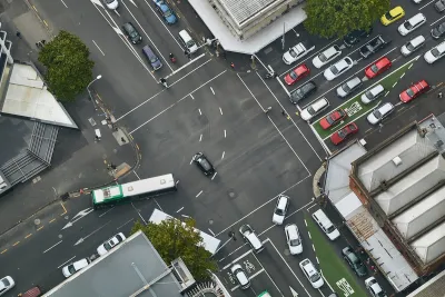
Are we neglecting key data about near-misses at intersections in urban mobility and road safety? An article in Cities Today argues that, while many cities are redesigning intersections to improve safety using crash reports, “one critical layer of data is often missing: insight into what almost went wrong.”
The article posits that paying closer attention to near-misses can offer “a transformative addition to traditional urban traffic planning” and help planners understand dangerous intersections before fatal crashes occur.
According to Cities Today, “To fill this gap, Flow Analytics by AGC applies high-resolution LiDAR and AI-based trajectory analysis to monitor the movement of all road users, including vehicles, cyclists, and pedestrians. The system observes these interactions in real time, identifying conflict points as they happen.”
Several European cities are already testing the technology to detect and act on near misses. “New technologies are enabling cities to understand not just where people travel, but how those journeys unfold—and where conflicts occur. By capturing these dynamics, near-miss detection helps uncover risks that conventional systems might miss entirely.”
FULL STORY: What cities miss at intersections, and why it’s costing us more than we think


Pittsburgh Agencies Collaborate on Vision Zero Projects
The city reduced pedestrian deaths to seven in 2023.

Pedestrian Deaths Drop, Remain Twice as High as in 2009
Fatalities declined by 4 percent in 2024, but the U.S. is still nowhere close to ‘Vision Zero.’

Vehicle-related Deaths Drop 29% in Richmond, VA
The seventh year of the city's Vision Zero strategy also cut the number of people killed in alcohol-related crashes by half.

Maui's Vacation Rental Debate Turns Ugly
Verbal attacks, misinformation campaigns and fistfights plague a high-stakes debate to convert thousands of vacation rentals into long-term housing.

Planetizen Federal Action Tracker
A weekly monitor of how Trump’s orders and actions are impacting planners and planning in America.

In Urban Planning, AI Prompting Could be the New Design Thinking
Creativity has long been key to great urban design. What if we see AI as our new creative partner?

California Creates Housing-Focused Agency
Previously, the state’s housing and homelessness programs fell under a grabbag department that also regulates the alcohol industry, car mechanics, and horse racing.

Chicago’s Ghost Rails
Just beneath the surface of the modern city lie the remnants of its expansive early 20th-century streetcar system.

Baker Creek Pavilion: Blending Nature and Architecture in Knoxville
Knoxville’s urban wilderness planning initiative unveils the "Baker Creek Pavilion" to increase the city's access to green spaces.
Urban Design for Planners 1: Software Tools
This six-course series explores essential urban design concepts using open source software and equips planners with the tools they need to participate fully in the urban design process.
Planning for Universal Design
Learn the tools for implementing Universal Design in planning regulations.
planning NEXT
Appalachian Highlands Housing Partners
Mpact (founded as Rail~Volution)
City of Camden Redevelopment Agency
City of Astoria
City of Portland
City of Laramie