


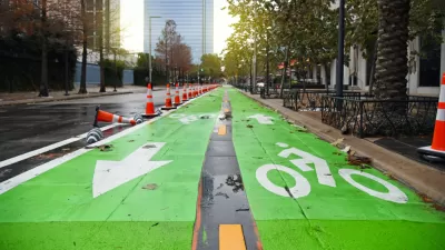
Community members, aided in part by funding from the city, repurposed a vehicle lane to create a protected bike and pedestrian path for the summer season.

A group of neighbors in Indianapolis led an effort to create a temporary multi-use path on the Calvary Street Bridge to illustrate the potential of bike- and pedestrian-oriented safety improvements.
As Jordan Smith reports in the Indianapolis Star, the project was spearheaded by community members from the Fletcher Place and Fountain Square neighborhoods and partially funded by the city. “The city contributed a $6,500 grant for the neighbors' "tactical urbanism" project through its Community Powered Infrastructure program, which matches dollars raised by local groups to improve roads, sidewalks and multi-use paths.”
“The two neighborhoods partnered this weekend to place more than 60 traffic barriers along the southernmost lane of the Calvary Street bridge, where the new path runs. They also painted the road and set up several new curb extensions to calm traffic along nearby McCarty Street.” The same community members have been monitoring traffic speeds on their local streets, which led to the addition of temporary curb bumpouts on some streets to slow traffic.
The current projects will last through October, when the city will need to use the space to operate snowplows. However, the neighbors involved hope to make the changes permanent next year.
FULL STORY: Indianapolis neighbors near I-65/I-70 South Split shut down lane for pedestrian path

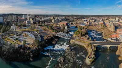
Spokane Launches Safe Streets Initiative
The Washington city received a $9.6 million federal grant to fund quick-build traffic calming and bike and pedestrian infrastructure projects.
Safe Streets Funding in Jeopardy
The Trump administration is specifically targeting bike infrastructure and other road safety projects in its funding cuts.
Houston Mayor Pauses Complete Streets Projects
The move raises concerns among road safety advocates who point out that traffic deaths continue to rise.

Montreal Mall to Become 6,000 Housing Units
Place Versailles will be transformed into a mixed-use complex over the next 25 years.

Planetizen Federal Action Tracker
A weekly monitor of how Trump’s orders and actions are impacting planners and planning in America.

DARTSpace Platform Streamlines Dallas TOD Application Process
The Dallas transit agency hopes a shorter permitting timeline will boost transit-oriented development around rail stations.

Bicycles and Books — In Sacramento, Libraries Now Offer Both
Adult library card holders can check out e-bikes and e-trikes for up to one week.

Colorado Landfills Emit as Much Pollution as 1M Cars
Landfills are the third-largest source of methane pollution in Colorado, after agriculture and fossil fuel extraction.

Tulsa Paid Remote Workers $10,000 to Move In — Nearly All of Them Stayed
The Tulsa Remote program generated more than $4 in local economic benefits for every dollar spent.
Urban Design for Planners 1: Software Tools
This six-course series explores essential urban design concepts using open source software and equips planners with the tools they need to participate fully in the urban design process.
Planning for Universal Design
Learn the tools for implementing Universal Design in planning regulations.
City of Mt Shasta
City of Camden Redevelopment Agency
City of Astoria
Transportation Research & Education Center (TREC) at Portland State University
City of Camden Redevelopment Agency
Municipality of Princeton (NJ)
Regional Transportation Commission of Southern Nevada