


Researchers are using artificial intelligence, drones, and sensors to locate and assess undocumented orphaned oil and gas wells, addressing their environmental and climate risks by identifying high-priority sites for plugging and methane mitigation.
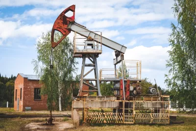
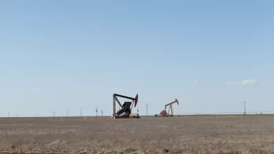
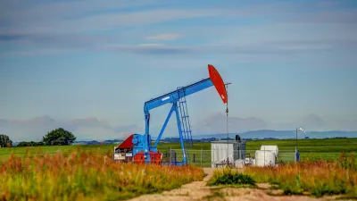
Undocumented orphaned oil and gas wells scattered across the United States pose significant environmental and climate risks, with potential leaks contaminating air, water, and emitting methane, a potent greenhouse gas. Leveraging artificial intelligence (AI), researchers are analyzing historical topographic maps to identify these hidden wells, combining this data with modern tools like drones, sensors, and magnetometers to locate and assess the sites. The AI technology, trained to recognize symbols denoting wells on old maps, has already pinpointed thousands of potential undocumented wells, which are then verified through satellite imagery and fieldwork.
The research is part of the Consortium Advancing Technology for Assessment of Lost Oil & Gas Wells (CATALOG), a collaborative effort among national labs to address the growing issue of orphan wells. Once discovered, these wells are assessed for methane emissions using both high-tech and low-cost sensors to prioritize the most hazardous sites for plugging. This approach not only curbs greenhouse gas emissions but also prevents contaminants like benzene and hydrogen sulfide from endangering nearby ecosystems and communities.
Innovative field tools, such as drones equipped with methane sensors and magnetometers, allow researchers to survey large areas more efficiently than on foot. These technologies are paired with traditional mapping techniques to create a multi-layered approach for uncovering wells. The combination of historical data and cutting-edge equipment ensures even wells buried under decades of development or natural regrowth can be identified and addressed.
Through partnerships with stakeholders like Native American tribes and federal agencies, CATALOG’s efforts aim to scale these methods nationwide. By integrating diverse datasets and tools, the project seeks to minimize environmental harm from orphan wells, reducing methane emissions and protecting communities from the legacy of early oil and gas exploration.
FULL STORY: AI Helps Researchers Dig Through Old Maps to Find Lost Oil and Gas Wells

Silent Threat: America’s Abandoned Oil Wells and the Danger Beneath
Abandoned oil and gas wells across the U.S. pose significant environmental, health, and safety risks, with many leaking hazardous gases and chemicals, highlighting regulatory failures and the immense financial burden of remediation.

Using Old Oil and Gas Wells for Green Energy Storage
Penn State researchers have found that repurposing abandoned oil and gas wells for geothermal-assisted compressed-air energy storage can boost efficiency, reduce environmental risks, and support clean energy and job transitions.
Alberta’s Orphan Well Cleanup Plan Sparks Debate Over Use of Public Funds
Alberta’s upcoming plan to address nearly 80,000 abandoned oil wells has sparked controversy over the potential use of public funds, despite government claims that taxpayers won’t be footing the bill.

Planetizen Federal Action Tracker
A weekly monitor of how Trump’s orders and actions are impacting planners and planning in America.

Congressman Proposes Bill to Rename DC Metro “Trump Train”
The Make Autorail Great Again Act would withhold federal funding to the system until the Washington Metropolitan Area Transit Authority (WMATA), rebrands as the Washington Metropolitan Authority for Greater Access (WMAGA).

The Simple Legislative Tool Transforming Vacant Downtowns
In California, Michigan and Georgia, an easy win is bringing dollars — and delight — back to city centers.

The States Losing Rural Delivery Rooms at an Alarming Pace
In some states, as few as 9% of rural hospitals still deliver babies. As a result, rising pre-term births, no adequate pre-term care and "harrowing" close calls are a growing reality.

The Small South Asian Republic Going all in on EVs
Thanks to one simple policy change less than five years ago, 65% of new cars in this Himalayan country are now electric.

DC Backpedals on Bike Lane Protection, Swaps Barriers for Paint
Citing aesthetic concerns, the city is removing the concrete barriers and flexposts that once separated Arizona Avenue cyclists from motor vehicles.
Urban Design for Planners 1: Software Tools
This six-course series explores essential urban design concepts using open source software and equips planners with the tools they need to participate fully in the urban design process.
Planning for Universal Design
Learn the tools for implementing Universal Design in planning regulations.
Smith Gee Studio
City of Charlotte
City of Camden Redevelopment Agency
City of Astoria
Transportation Research & Education Center (TREC) at Portland State University
US High Speed Rail Association
City of Camden Redevelopment Agency
Municipality of Princeton (NJ)