


Three-fourths of counties with the highest pedestrian death rates also had persistently high poverty rates, according to a Stateline article.
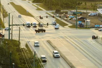
Pedestrian deaths have dropped nationally after three years of increases but are still 14 percent higher than before the pandemic, reports Tim Henderson of Stateline. Analysis by Stateline of how those rates are playing out across the country has revealed that pedestrians are dying at the highest rates, not in big cities with crowded sidewalks, “but in Western and Southern rural areas and small cities where poverty forces more people to walk on dark highways with inadequate sidewalks or shoulders.” Henderson reports.
“[A]cross the country, the 33 counties with the highest rates — each with more than twice the national rate of 2.5 pedestrian deaths per 100,000 — are mostly in the South and West,” according to the Stateline article. While big cities like Los Angeles, Phoenix, and Houston had the highest numbers of pedestrian dates, the rates per resident were lower. Of the counties with the highest rates, more than three-fourths have poverty rates above 20 percent, and pedestrian deaths tend to occur in high-poverty areas within those counties.
Another commonality? The deadly stroad — a mix between a street and road — which tries to balance the incompatible roles of facilitating foot traffic while also trying to move cars quickly. The combination of stroads and concentrations of low-income people who are less likely to own cars means people with lower incomes, including unhoused people, are more likely to be walking alongside and crossing roads in the most dangerous areas, according to the article.
FULL STORY: Social Issues Society Transportation Dark highways, fast cars, few sidewalks — and more pedestrian deaths

Study: Large SUVs Double Risk of Death for Children Under 10
New research from the United Kingdom reveals the higher risk of larger vehicles for pedestrians and cyclists.
OKC Releases Draft Vision Zero Plan
The plan identifies a High Injury Network and strategies for improving road safety on Oklahoma City streets.
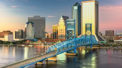
Jacksonville Takes Action on Vision Zero
The city is implementing its first-ever Vision Zero Action Plan in an effort to reduce pedestrian and cyclist deaths and serious injuries.

Maui's Vacation Rental Debate Turns Ugly
Verbal attacks, misinformation campaigns and fistfights plague a high-stakes debate to convert thousands of vacation rentals into long-term housing.

Planetizen Federal Action Tracker
A weekly monitor of how Trump’s orders and actions are impacting planners and planning in America.

In Urban Planning, AI Prompting Could be the New Design Thinking
Creativity has long been key to great urban design. What if we see AI as our new creative partner?

How Trump's HUD Budget Proposal Would Harm Homelessness Response
Experts say the change to the HUD budget would make it more difficult to identify people who are homeless and connect them with services, and to prevent homelessness.

The Vast Potential of the Right-of-Way
One writer argues that the space between two building faces is the most important element of the built environment.

Florida Seniors Face Rising Homelessness Risk
High housing costs are pushing more seniors, many of them on a fixed income, into homelessness.
Urban Design for Planners 1: Software Tools
This six-course series explores essential urban design concepts using open source software and equips planners with the tools they need to participate fully in the urban design process.
Planning for Universal Design
Learn the tools for implementing Universal Design in planning regulations.
Gallatin County Department of Planning & Community Development
Heyer Gruel & Associates PA
JM Goldson LLC
Mpact (founded as Rail~Volution)
City of Camden Redevelopment Agency
City of Astoria
Jefferson Parish Government
Camden Redevelopment Agency
City of Claremont