


Caltrans will soon close half of the 101 Freeway in order to continue construction of the Wallis Annenberg Wildlife Crossing near Agoura Hills in Los Angeles County.
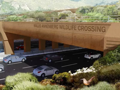
Located at Liberty Canyon and the 101 Freeway, the Wallis Annenberg Wildlife Crossing is a public-private partnership that has leveraged the expertise and leadership of numerous organizations and institutions. The core partners include Caltrans, the National Park Service, the Santa Monica Mountains Conservancy, Mountains Recreation and Conservation Authority, Resource Conservation District of the Santa Monica Mountains, and the National Wildlife Federation.
The purpose of the project is to provide a safe and sustainable passage for wildlife across the 101 Freeway near Liberty Canyon Road in Agoura Hills to reduce wildlife death and allow for the movement of animals and the exchange of genetic material. Without a safe and sustainable wildlife crossing, movement between these remaining areas of natural habitat is severely restricted and wildlife within the Santa Monica Mountains is essentially trapped.
As reported by Makenna Sievertson in this article, Caltrans will be closing all southbound lanes of the 101 Freeway in Agoura Hills for five hours each night for construction on the wildlife crossing starting Monday, April 15th, 2024. Specifically, crews will be installing the first girders, an approximately 100-foot-long box of reinforced concrete that will serve as the base level of the wildlife crossing. The girders will help support the structure’s horizontal reach across one of the country’s busiest highways.
The closure will extend from Liberty Canyon to Chesebro roads, but the northbound lanes will remain open and there will be detours available for drivers. Breaking ground on Earth Day in 2022, the project is anticipated to be completed by early 2026. For additional information, please read the source article.
FULL STORY: Wildlife Crossing Closures Coming For 101 Freeway

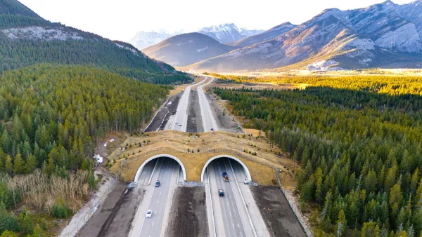
Where the Wild Things Cross
Wildlife-vehicle collisions cost Americans over $8 billion annually. The solution can be simple — and stunning.
California Room to Roam Act Prioritizes Wildlife Connectivity
A new state law requires new development and infrastructure to minimize disruption to local wildlife habitats and migration patterns.

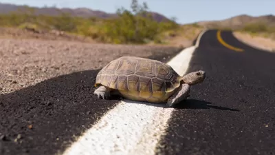
Cougar Death Highlights Urgent Need for Wildlife Crossing
A mountain lion was found dead on the 101 Freeway, less than half a mile from the steel and concrete endoskeleton of the Wallis Annenberg Wildlife Crossing.

Planetizen Federal Action Tracker
A weekly monitor of how Trump’s orders and actions are impacting planners and planning in America.

San Francisco's School District Spent $105M To Build Affordable Housing for Teachers — And That's Just the Beginning
SFUSD joins a growing list of school districts using their land holdings to address housing affordability challenges faced by their own employees.

The Tiny, Adorable $7,000 Car Turning Japan Onto EVs
The single seat Mibot charges from a regular plug as quickly as an iPad, and is about half the price of an average EV.

Seattle's Plan for Adopting Driverless Cars
Equity, safety, accessibility and affordability are front of mind as the city prepares for robotaxis and other autonomous vehicles.

As Trump Phases Out FEMA, Is It Time to Flee the Floodplains?
With less federal funding available for disaster relief efforts, the need to relocate at-risk communities is more urgent than ever.

With Protected Lanes, 460% More People Commute by Bike
For those needing more ammo, more data proving what we already knew is here.
Urban Design for Planners 1: Software Tools
This six-course series explores essential urban design concepts using open source software and equips planners with the tools they need to participate fully in the urban design process.
Planning for Universal Design
Learn the tools for implementing Universal Design in planning regulations.
Smith Gee Studio
City of Charlotte
City of Camden Redevelopment Agency
City of Astoria
Transportation Research & Education Center (TREC) at Portland State University
US High Speed Rail Association
City of Camden Redevelopment Agency
Municipality of Princeton (NJ)