


The County of Los Angeles recently launched a website to better connect residents of unincorporated areas to information and municipal services offered by the county.
The County of Los Angeles is the most populous and complicated county in the U.S., responsible for developing policies and delivering services to meet the needs of ten million residents, of which one million are living in unincorporated areas which are communities outside of city jurisdictions that have no local mayor or city council. Over 65% of L.A. County's 4,000-square mile land area is unincorporated. There are about 120 to 125 unincorporated areas, which range in size from a few blocks in size to larger urban centers with more than 150,000 residents.
Residents of unincorporated areas rely on L.A. County and their County supervisor for local government representation and services, including land use planning and zoning, parks and recreation, public libraries, public safety, environmental protection, emergency response, code enforcement, homelessness crisis response and other critical services and initiatives.
The County recently created and launched a new website where residents of unincorporated areas can find answers to questions like:
- Who is their County representative?
- What are the municipal serves available to them?
- Which departments do they contact for more information about specific services?
- How to they for apply for permits, register for services, report issues and complaints, and request important documents?
Also available on the website are guides to municipal and unincorporated area services in English and Spanish organized by supervisorial district as well as responses to frequently asked questions.
FULL STORY: Unincorporated Area Services - County of Los Angeles


What Community-Based Zoning Enforcement Looks Like in South Central Los Angeles
Passion for urban planning, love of South Central LA communities, and historical background of the neighborhoods combine in this personal account by Jonathan P. Bell of community-based zoning enforcement.
Los Angeles County's Creative Plans to Boost Parks
A recent Los Angeles Times article described the creative ways the city of Los Angeles is trying to meet park needs. Los Angeles County park planner Clement Lau describes the county's side of the story.
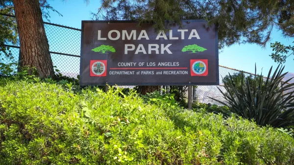
A Park Reborn: Resilience and Renewal in Fire-Stricken Altadena
Rebuilt in just two months after the devastating Eaton Fire, Loma Alta Park now stands as a symbol of community resilience and renewal, even as some residents hope recovery efforts will continue to support housing stability and long-term equity.

Maui's Vacation Rental Debate Turns Ugly
Verbal attacks, misinformation campaigns and fistfights plague a high-stakes debate to convert thousands of vacation rentals into long-term housing.

Planetizen Federal Action Tracker
A weekly monitor of how Trump’s orders and actions are impacting planners and planning in America.

San Francisco Suspends Traffic Calming Amidst Record Deaths
Citing “a challenging fiscal landscape,” the city will cease the program on the heels of 42 traffic deaths, including 24 pedestrians.

Half of Post-Fire Altadena Home Sales Were to Corporations
Large investors are quietly buying up dozens of properties in Altadena, California, where a devastating wildfire destroyed more than 6,000 homes in January.

Opinion: What San Francisco’s Proposed ‘Family Zoning’ Could Really Mean
Mayor Lurie is using ‘family zoning’ to encourage denser development and upzoning — but could the concept actually foster community and more human-scale public spaces?

Jacksonville Launches First Autonomous Transit Shuttle in US
A fleet of 14 fully autonomous vehicles will serve a 3.5-mile downtown Jacksonville route with 12 stops.
Urban Design for Planners 1: Software Tools
This six-course series explores essential urban design concepts using open source software and equips planners with the tools they need to participate fully in the urban design process.
Planning for Universal Design
Learn the tools for implementing Universal Design in planning regulations.
Gallatin County Department of Planning & Community Development
Heyer Gruel & Associates PA
JM Goldson LLC
City of Camden Redevelopment Agency
City of Astoria
Transportation Research & Education Center (TREC) at Portland State University
Jefferson Parish Government
Camden Redevelopment Agency
City of Claremont