


The city of Danville, located along the Easy Bay Area’s I-680 corridor, last week approved a new master plan for its downtown, with funding for implementation made possible by the American Rescue Plan Act.
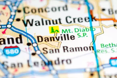
Jeanita Lyman reports on a new master plan for Danville, just prior to a vote by the Danville City Council to approve the plan. The article cites Jill Bergman, Danville's business and economic development director, to describe the plan as a response to the economic disruptions of the Covid-19 pandemic.
“The proposed update aims to address the top three priorities identified in a number of public outreach efforts. These consist of improvements along Hartz Avenue, expansions to the Theatre Plaza and public plaza at Hartz Avenue and Prospect Street, and addressing traffic safety concerns,” writes Lyman.
Street configuration changes will include intersection bulb-outs, raised intersection tables, and ‘expanded areas at intersections for specialty art lighting to enhance nighttime visibility.’
Bergman also informs readers that Danville has funding from the American Rescue Plan Act to fund some of the implementation of the plan.
FULL STORY: Danville council to vote on Downtown Master Plan update


Building on Recent Planning Success in Akron
Following the success of Planning to Grow Akron, spurring the development of thousands of housing units in the previously stagnant city, Planning to Grow Akron 2.0 will leverage federal stimulus funds to further stabilize the city's housing market.
'American Jobs Plan': Potential Sea Change for Federal Infrastructure Spending
After a week of speculation and rumor, the Biden administration today revealed its promised infrastructure plan.

Placemaking Redefined by a New Era of Federal Investment
Six tips for ensuring that new placed-based funding programs, such as the Build Back Better Regional Challenge, achieve the full potential of a new era of place-based federal investment.

Planetizen Federal Action Tracker
A weekly monitor of how Trump’s orders and actions are impacting planners and planning in America.

Congressman Proposes Bill to Rename DC Metro “Trump Train”
The Make Autorail Great Again Act would withhold federal funding to the system until the Washington Metropolitan Area Transit Authority (WMATA), rebrands as the Washington Metropolitan Authority for Greater Access (WMAGA).

DARTSpace Platform Streamlines Dallas TOD Application Process
The Dallas transit agency hopes a shorter permitting timeline will boost transit-oriented development around rail stations.

San Francisco's School District Spent $105M To Build Affordable Housing for Teachers — And That's Just the Beginning
SFUSD joins a growing list of school districts using their land holdings to address housing affordability challenges faced by their own employees.

Car-Centric LA Suburb Looks to a Train-Oriented Future
City leaders in Rancho Cucamonga, the future western terminus of the Brightline West rail line to Las Vegas, want to reimagine the city as a transit-oriented, pedestrian-friendly community.

New Alaska Bitcoin Mine Would Burn as Much Energy as the State’s Largest Coal Plant
Fueled by “stranded” natural gas, the startup hopes to become the largest in the US, and to make Alaska an industry center.
Urban Design for Planners 1: Software Tools
This six-course series explores essential urban design concepts using open source software and equips planners with the tools they need to participate fully in the urban design process.
Planning for Universal Design
Learn the tools for implementing Universal Design in planning regulations.
Municipality of Princeton
Roanoke Valley-Alleghany Regional Commission
City of Mt Shasta
City of Camden Redevelopment Agency
City of Astoria
Transportation Research & Education Center (TREC) at Portland State University
US High Speed Rail Association
City of Camden Redevelopment Agency
Municipality of Princeton (NJ)