


Local officials hope to use federal infrastructure funding to make safety improvements on Roosevelt Boulevard, where more than a tenth of the city’s traffic deaths happen.
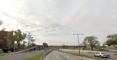
Philadelphia’s Roosevelt Boulevard, a notoriously dangerous corridor, saw 10 to 13 percent of the city’s total traffic fatalities every year before the pandemic, reports Claudia Lauer for Insurance Journal. “Roosevelt Boulevard is an almost 14-mile maze of chaotic traffic patterns that passes through some of the city’s most diverse neighborhoods and census tracts with the highest poverty rates. Driving can be dangerous with cars traversing between inner and outer lanes, but biking or walking on the boulevard can be even worse with some pedestrian crossings longer than a football field and taking four light cycles to cross.”
Safety advocates hope to see changes coming to the street soon. “Kelley Yemen, director of Philadelphia’s Complete Streets program, said the city is hoping for federal money to begin a long-term redesign of Roosevelt outlined in a study released in 2019. The two options would either make the center lanes a restricted expressway, or cut speeds and convert car lanes to bicycle and transit lanes. Both carry billion-dollar price tags.”
Despite the reduction in overall traffic during the early days of the pandemic, “Around Philadelphia, aggressive driving during the pandemic drove fatalities to 156 in 2020, a sharp increase from 90 deaths in 2019,” notes Lauer. “Data for the first four months of 2022 showed more pedestrians died on Philadelphia roads so far this year than people in cars.”
In an encouraging sign, fatalities on Roosevelt Boulevard did not increase like in much of the city. Safety advocates attribute this to the automated traffic enforcement program that installed speed cameras at eight intersections. “Overall, speeding is down by more than 91% on the road, city and parking authority officials said.”
FULL STORY: Road Safety Strategy Offers Hope for Redesign of Philadelphia’s ‘Corridor of Death’

How “Proven Safety Countermeasures” Save Lives
A bill named in honor of a U.S. diplomat killed while on her bicycle would let state DOTs access full federal funding for road safety projects.

Moving Beyond Crash Statistics to Understand Road Safety
Why measuring traffic deaths alone doesn’t paint a full picture.
Philly Road Safety Advocates Call for Action From the City
Mayor Parker’s administration is proposing massive cuts to the city’s Vision Zero program while pedestrian and cyclist deaths remain high.

Planetizen Federal Action Tracker
A weekly monitor of how Trump’s orders and actions are impacting planners and planning in America.

DARTSpace Platform Streamlines Dallas TOD Application Process
The Dallas transit agency hopes a shorter permitting timeline will boost transit-oriented development around rail stations.

Congressman Proposes Bill to Rename DC Metro “Trump Train”
The Make Autorail Great Again Act would withhold federal funding to the system until the Washington Metropolitan Area Transit Authority (WMATA), rebrands as the Washington Metropolitan Authority for Greater Access (WMAGA).

Supreme Court Ruling in Pipeline Case Guts Federal Environmental Law
The decision limits the scope of a federal law that mandates extensive environmental impact reviews of energy, infrastructure, and transportation projects.

Texas State Bills to Defund Dallas Transit Die
DART would have seen a 30% service cut, $230M annual losses had the bills survived.

Bikeshare for the Win: Team Pedals to London Cricket Match, Beats Rivals Stuck in Traffic
While their opponents sat in gridlock, England's national cricket team hopped Lime bikes, riding to a 3-0 victory.
Urban Design for Planners 1: Software Tools
This six-course series explores essential urban design concepts using open source software and equips planners with the tools they need to participate fully in the urban design process.
Planning for Universal Design
Learn the tools for implementing Universal Design in planning regulations.
Roanoke Valley-Alleghany Regional Commission
City of Mt Shasta
City of Camden Redevelopment Agency
City of Astoria
Transportation Research & Education Center (TREC) at Portland State University
US High Speed Rail Association
City of Camden Redevelopment Agency
Municipality of Princeton (NJ)