


The city of Paradise is employing a natural hazard mitigation strategy long practiced in flood zones. The idea could be expanded in other places where wildland meets human development.
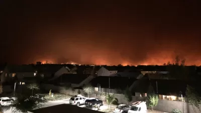
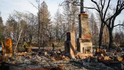
As wildfires once again rage across the Western United States, NPR's Morning Edition recently returned to Paradise, California, where the 2018 Camp Fire raced through the town, killing 85 people and destroying about 19,000 structures.
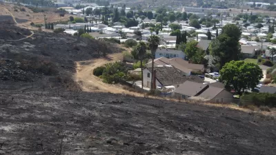
To prevent the same tragedy again, Paradise is identifying and buying high risk properties in the Camp Fire burn area. Where willing sellers are found on high risk properties, the city buys the property and transforms the land into fire resistant green spaces.
"The idea is to connect the burnt out lots to the town's existing park land," according to the article. "That's good for adding more recreation but it could also work as a fuel break."
This is not a program relying on eminent domain. So far, the city has "acquired about 300 acres of new land, with about 500 more acres in the pipeline, mostly paid for with non profit grant money and donations."
Dan Efseaff, director of the Paradise Recreation and District, is quoted extensively in the article, including a statement that the city needs $20 million more to have a serious impact on the risk of wildfire.
As noted in the article, the government has been buying back properties in flood areas for decades. "And as the West cooks in extreme drought, there's interest in replicating this in certain high risk fire zones. A change in federal law recently devoted funding to study the feasibility of this in places like the Sierra Nevada, and Paradise is eager for federal support."
For more details of how these private properties can be transformed into fire resistant park space, read an article written recently by Jonah Susskind for the American Society of Landscape Architect's blog. Susskind describes this kind of fire resistant park space as Wildfire Risk Reduction Buffers (WRRBs).
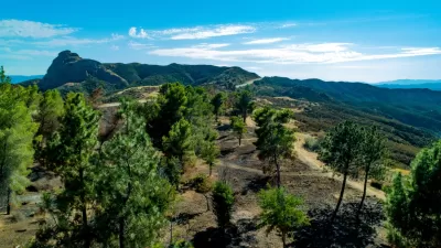
The basic concept ensures that combustible materials and flammable vegetation is cleared from the area immediately around structures, and that certain vegetation management guidelines are followed further out (typically in designated zones between 5 and 100 feet). Essentially, the WRRB idea takes this approach and scales it up to the size of the whole community by ensuring that lower-risk land uses are maintained between developed areas and undeveloped wildlands.
The article also describes an effort by SWA Group to take the concept even further by "using these greenbelts as a spatial framework for reintroducing prescribed fire into the landscape in order to reduce regional fuel loads while simultaneously enhancing the ecological health of densely forested areas."
FULL STORY: In Fire Scorched California, Town Aims To Buy The Highest At-Risk Properties

In Paradise, Using Greenbelts to Manage Wildfires
The Camp Fire in California devasted the town of Paradise. As rebuilding progresses, local leaders are looking to protect the town using nature-based fire resilience strategies.
Resilient Communities, Healthy Ecosystems: A Balanced Approach to Wildfires
Effective wildfire mitigation in California requires a holistic approach that goes beyond large-scale vegetation removal, emphasizing home hardening, defensible space, strategic planning, and reducing human-caused ignitions.
Fire-Ravaged Paradise Plans for a Resilient Rebirth
A new urban design plan calls for a robust buffer zone to protect the town from fast-spreading fires, among other mitigation measures.

Maui's Vacation Rental Debate Turns Ugly
Verbal attacks, misinformation campaigns and fistfights plague a high-stakes debate to convert thousands of vacation rentals into long-term housing.

Planetizen Federal Action Tracker
A weekly monitor of how Trump’s orders and actions are impacting planners and planning in America.

San Francisco Suspends Traffic Calming Amidst Record Deaths
Citing “a challenging fiscal landscape,” the city will cease the program on the heels of 42 traffic deaths, including 24 pedestrians.

Adaptive Reuse Will Create Housing in a Suburban Texas Strip Mall
A developer is reimagining a strip mall property as a mixed-use complex with housing and retail.

Study: Anti-Homelessness Laws Don’t Work
Research shows that punitive measures that criminalized unhoused people don’t help reduce homelessness.

In U.S., Urban Gondolas Face Uphill Battle
Cities in Latin America and Europe have embraced aerial transitways — AKA gondolas — as sustainable, convenient urban transport, especially in tricky geographies. American cities have yet to catch up.
Urban Design for Planners 1: Software Tools
This six-course series explores essential urban design concepts using open source software and equips planners with the tools they need to participate fully in the urban design process.
Planning for Universal Design
Learn the tools for implementing Universal Design in planning regulations.
Heyer Gruel & Associates PA
JM Goldson LLC
Custer County Colorado
City of Camden Redevelopment Agency
City of Astoria
Transportation Research & Education Center (TREC) at Portland State University
Jefferson Parish Government
Camden Redevelopment Agency
City of Claremont