


A new draft Los Angeles Master Plan, created by Frank Gehry's firm, lays out a more active, natural vision for the river, in addition to addressing concerns about displacement in communities along the river corridor.

Los Angeles County this week released a draft update to the Los Angeles River Master Plan.
Steven Sharp reports on the document, which is "intended to guide the development of new parks and water quality projects along the 51-mile corridor, while also accounting for potential displacement and equity issues in neighboring communities."
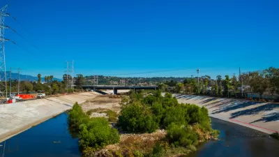
The Los Angeles River was infamously encased in concrete after a series of destructive storms in the early 20th century, but, as Sharp notes, "sparse rainfall in Southern California mean's that the river is only needed for its flood control functions roughly 2 percent of the time [.....] That creates an opportunity for recreational activities and public open space on much of the corridor."
Sharp summarizes some of the plan's approach to development potential along the river thusly:
Although the master plan does not effectuate any specific investments along the river, the document identifies 56 potential projects between the San Fernando Valley and the South Bay. In addition to building off of existing proposals - such as a 42-acre park at the Taylor Yard or the Downtown leg of the L.A. River bike path - the plan includes a "kit of parts" outlining an array of improvements to the channel, ranging from more modest river trails to channel modifications and even flood plain reclamation.
The county hired architect Frank Gehry's firm, working with landscape architect Laurie Olin, to complete the master plan. An article by Louis Sahagún for the Los Angeles Times devotes more ink to the starchitect angle inherent to the release of the draft master plan. Olin's contribution to the plan, according to Sharp, is a vision for "100 miles of public trails along the river, as well as park projects that restore habitats and improve water quality."
Gehry's role on the Los Angeles River has been controversial in the past. Gehry's firm was working in the background without public attention early in the process, but Gehry's initial work focused on hydrology, so the scope of the planning work has clearly expanded since then. At the time, concerns included a lack of understanding about how Gehry's work fit in with the Los Angeles River Revitalization Mater Plan, approved in 2007, and a plan released in 2013 by the U.S. Army Corps of Engineers that shifted the focus of planning and engineering along the river to include habitat restoration in addition to stormwater protection.
FULL STORY: Here's a Look at the Updated L.A. River Master Plan


Los Angeles County: It's Time to Update the Master Plan for the L.A. River
The Los Angeles County Board of Supervisors voted this week to begin the processing of updating the 20-year-old Los Angeles River Master Plan.
A Comment for the L.A. River Master Plan
Five themes proposed to achieve justice and sustainability for the Los Angeles River and its surrounding communities.

Gehry's Plans for Los Angeles River Restoration Gaining Clarity
Details are emerging in the controversial effort by Gehry Partners, LLP to plan a new vision for the Los Angeles River. So far, however, Gehry Partners seems to have been listening more than plotting or drawing.

Montreal Mall to Become 6,000 Housing Units
Place Versailles will be transformed into a mixed-use complex over the next 25 years.

Planetizen Federal Action Tracker
A weekly monitor of how Trump’s orders and actions are impacting planners and planning in America.

DARTSpace Platform Streamlines Dallas TOD Application Process
The Dallas transit agency hopes a shorter permitting timeline will boost transit-oriented development around rail stations.

Nine Ways to Use Curb Space That Aren’t Parking
California’s new daylighting law bans parking within 20 feet of crosswalks. How can cities best use this space?

ADUs for Sale? San Diego Could Legalize Backyard Condos
As one of 25 proposed amendments, San Diego may soon allow accessory dwelling units to be bought and sold as individual homes.

Dallas Ditches Parking Minimums in 14-1 Vote
The sweeping city council decision removes set parking requirements from developments downtown, near transit, small businesses and more.
Urban Design for Planners 1: Software Tools
This six-course series explores essential urban design concepts using open source software and equips planners with the tools they need to participate fully in the urban design process.
Planning for Universal Design
Learn the tools for implementing Universal Design in planning regulations.
City of Mt Shasta
City of Camden Redevelopment Agency
City of Astoria
Transportation Research & Education Center (TREC) at Portland State University
City of Camden Redevelopment Agency
Municipality of Princeton (NJ)
Regional Transportation Commission of Southern Nevada