


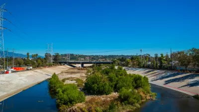
The Los Angeles County Board of Supervisors voted this week to begin the processing of updating the 20-year-old Los Angeles River Master Plan.

"A 20-year-old plan mapping the future of the LA River is getting an update," reports Elijah Chiland. "The County Board of Supervisors voted Tuesday to update the LA River Master Plan, called for by the board in 1991 and adopted five years later."
L.A. County Supervisor Sheila Kuehl put out a press release to announce the plan update, coining a clever term in the process:
In order to avoid ‘plan-demonium,’ this motion is designed to ensure that the LA River Master Plan engages all stakeholders and develops a unified vision that reflects the needs of all communities and includes all voices.”
According to the press release, the first step of the master plan update is to establish a steering committee of regional agencies, city leaders, nonprofit and community groups, and other interested stakeholders. The motion also ensures input from County Departments, including representatives from the city of Los Angeles, the LA County Flood Control District and the U.S. Army Corps of Engineers.
Stephanie Michaud provides additional coverage of the approval of the planning update. In that article, a telling anecdote from the board of supervisors hearing that produced the decision. According to Michaud, "Kuehl said the river has suffered not from neglect as much as from too much attention, with many organizations working independently to make changes."
FULL STORY: LOS ANGELES LA RIVER The 20-year-old LA River Master Plan is getting an update

A Comment for the L.A. River Master Plan
Five themes proposed to achieve justice and sustainability for the Los Angeles River and its surrounding communities.

Draft Los Angeles River Master Plan Revealed
A new draft Los Angeles Master Plan, created by Frank Gehry's firm, lays out a more active, natural vision for the river, in addition to addressing concerns about displacement in communities along the river corridor.

A New Master Plan for the Los Angeles River
The L.A. County Board of Supervisors voted to approved a new master plan for the L.A. River—the “Reimagined River.”

Planetizen Federal Action Tracker
A weekly monitor of how Trump’s orders and actions are impacting planners and planning in America.

Congressman Proposes Bill to Rename DC Metro “Trump Train”
The Make Autorail Great Again Act would withhold federal funding to the system until the Washington Metropolitan Area Transit Authority (WMATA), rebrands as the Washington Metropolitan Authority for Greater Access (WMAGA).

The Simple Legislative Tool Transforming Vacant Downtowns
In California, Michigan and Georgia, an easy win is bringing dollars — and delight — back to city centers.

The States Losing Rural Delivery Rooms at an Alarming Pace
In some states, as few as 9% of rural hospitals still deliver babies. As a result, rising pre-term births, no adequate pre-term care and "harrowing" close calls are a growing reality.

The Small South Asian Republic Going all in on EVs
Thanks to one simple policy change less than five years ago, 65% of new cars in this Himalayan country are now electric.

DC Backpedals on Bike Lane Protection, Swaps Barriers for Paint
Citing aesthetic concerns, the city is removing the concrete barriers and flexposts that once separated Arizona Avenue cyclists from motor vehicles.
Urban Design for Planners 1: Software Tools
This six-course series explores essential urban design concepts using open source software and equips planners with the tools they need to participate fully in the urban design process.
Planning for Universal Design
Learn the tools for implementing Universal Design in planning regulations.
Smith Gee Studio
City of Charlotte
City of Camden Redevelopment Agency
City of Astoria
Transportation Research & Education Center (TREC) at Portland State University
US High Speed Rail Association
City of Camden Redevelopment Agency
Municipality of Princeton (NJ)