


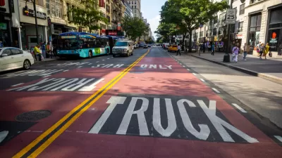
While it falls short of a more ambitious proposal pitched by the MTA recently, a new plan to expand bus priority on the streets of New York City would mark a significant expansion of a trend that started on 14th Street in Manhattan.
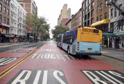
"Mayor de Blasio says he’ll create 20 miles of car-free busways and dedicated bus lanes across the city, starting this month — and make the successful 14th Street busway permanent," reports Gersh Kuntzman.
The total mileage falls short of the 60 miles of bus lanes and busways requested recently by the MTA, "but it's a start," according to Kuntzman.
The first new addition will be a busway on Main Street between Sanford and Northern Boulevard in Flushing. Car-free stretches of 1) Jamaica Avenue from Sutphin Boulevard to 168th Street; 2) Fifth Avenue in Manhattan, from 57th to 34th streets; 3) Jay Street in Brooklyn, from Fulton to Tillary streets; and 4) E. 181st St. in Manhattan, from Amsterdam Avenue to Broadway will follow, adding up to 3.5 miles of car-free streets.
Bus lanes will be added on 16.5 miles of streets: 1) 14th Street between First Avenue and Avenue C; 2) 149th Street in the Bronx from Southern Boulevard to River Avenue, 3) Merrick Boulevard in Queens from Hillside Avenue to Springfield Boulevard, and 4) Hylan Boulevard in Staten Island from Lincoln Avenue to Nelson Avenue.
More on the decision-making process and the response of a few advocacy organizations is included in the article.
FULL STORY: Mayor Creates More Busways — And Makes 14th Street Permanently Car-Free

Backtracking From Ambitious Bus Lane Promises in New York City
Back in June, the city of New York seemed poised for a major shift in transportation priority. In October, reality is setting in about how hard a sell the transformation will be.

New York's Bus Lane Program Slow to Start
It's a case of arrested development, as local opposition has derailed ambitious plans to greatly expand bus priority on streets around the city of New York.
Bus Priority Falling to Local Political Opposition in New York City
An ambitious program to add 20 miles of bus lanes and protected bus ways in the city of New York has been diminished by political opposition in parts of the city.

Planetizen Federal Action Tracker
A weekly monitor of how Trump’s orders and actions are impacting planners and planning in America.

Congressman Proposes Bill to Rename DC Metro “Trump Train”
The Make Autorail Great Again Act would withhold federal funding to the system until the Washington Metropolitan Area Transit Authority (WMATA), rebrands as the Washington Metropolitan Authority for Greater Access (WMAGA).

DARTSpace Platform Streamlines Dallas TOD Application Process
The Dallas transit agency hopes a shorter permitting timeline will boost transit-oriented development around rail stations.

LA County Creating Action Plan to Tackle Extreme Heat
Los Angeles County is creating a Heat Action Plan to help communities stay safe during extreme heat, with steps like adding more shade, improving buildings, and supporting the neighborhoods most at risk.

Maryland Plans Quick-Build Complete Streets Projects
The state will use low-cost interventions to improve road safety in five Maryland counties.

Downtown Los Angeles Gears Up for Growth
A new report highlights Downtown L.A.’s ongoing revival through major housing projects, adaptive reuse, hospitality growth, and preparations for global events in the years ahead.
Urban Design for Planners 1: Software Tools
This six-course series explores essential urban design concepts using open source software and equips planners with the tools they need to participate fully in the urban design process.
Planning for Universal Design
Learn the tools for implementing Universal Design in planning regulations.
City of Charlotte
Municipality of Princeton
Roanoke Valley-Alleghany Regional Commission
City of Camden Redevelopment Agency
City of Astoria
Transportation Research & Education Center (TREC) at Portland State University
US High Speed Rail Association
City of Camden Redevelopment Agency
Municipality of Princeton (NJ)