


Cities are not unlike brains in their capacity to evolve along complex, self-organizing patterns. Studying what some researchers call the "urban connectome" may give us insight into how best to organize the places where we live.
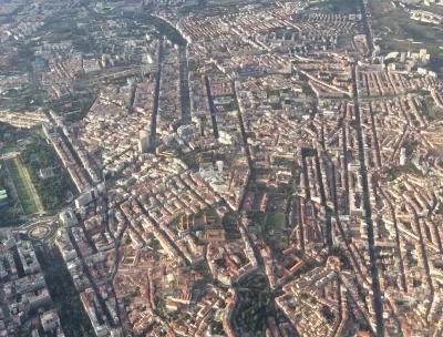
Urbanism and brain science are remarkably similar in some ways, Michael Mehaffy writes. "There is good reason to think that, as with brains, a lot of what happens in cities has more to do with the overall pattern of connections, and less to do with particular elements."
He goes on, "As Jane Jacobs pointed out over half a century ago, the city is a kind of 'intricate ballet' of people interacting, going about their plans, and shaping the life of the city, from the smallest scales to the largest." City folks thrive on knowledge spillovers, casual interactions with new people that give rise to novel enterprises and economic activity.
According to such a model, the health of cities depends on how effectively these kinds of "neural pathways" can form and reform. "In the case of cities, we have to ensure that we have well-connected, walkable cities, facilitating many cross-connections," Mehaffy writes.
The digital infrastructure of so-called smart cities can enhance such a network, but physical interactions between city dwellers form its foundation. "A corollary is that in our automobile-connected suburbs, it seems we have been replicating this pattern of connections—but only with heavy and unsustainable inputs of resources," Mehaffy says.
To get the most out of an urban connectome model, he goes on, we need to examine "the most effective patterns from a range of cities around the world—and over centuries of evolution."
FULL STORY: Wonders of the ‘urban connectome’


Looking Beyond the 'Sidewalk Ballet:' Jane Jacobs in the 21st Century
While The Death and Life of Great American Cities remains an urban planning classic, today's planners must contend with challenges that Jacobs couldn't have anticipated.
Jane Jacobs' Sidewalk Ballet, Gone Forever in New York City?
Alex Marshall discusses whether Jane Jacobs' famous "Sidewalk Ballet" is dead on the streets of New York City.

Expanding Access to Design Education at Honolulu Community College
Honolulu Community College’s Architecture, Engineering & Construction Technologies program highlights the role of community colleges in preparing nontraditional students for careers in architectural and construction technologies.

Planetizen Federal Action Tracker
A weekly monitor of how Trump’s orders and actions are impacting planners and planning in America.

Congressman Proposes Bill to Rename DC Metro “Trump Train”
The Make Autorail Great Again Act would withhold federal funding to the system until the Washington Metropolitan Area Transit Authority (WMATA), rebrands as the Washington Metropolitan Authority for Greater Access (WMAGA).

DARTSpace Platform Streamlines Dallas TOD Application Process
The Dallas transit agency hopes a shorter permitting timeline will boost transit-oriented development around rail stations.

San Francisco's School District Spent $105M To Build Affordable Housing for Teachers — And That's Just the Beginning
SFUSD joins a growing list of school districts using their land holdings to address housing affordability challenges faced by their own employees.

Car-Centric LA Suburb Looks to a Train-Oriented Future
City leaders in Rancho Cucamonga, the future western terminus of the Brightline West rail line to Las Vegas, want to reimagine the city as a transit-oriented, pedestrian-friendly community.

New Alaska Bitcoin Mine Would Burn as Much Energy as the State’s Largest Coal Plant
Fueled by “stranded” natural gas, the startup hopes to become the largest in the US, and to make Alaska an industry center.
Urban Design for Planners 1: Software Tools
This six-course series explores essential urban design concepts using open source software and equips planners with the tools they need to participate fully in the urban design process.
Planning for Universal Design
Learn the tools for implementing Universal Design in planning regulations.
Municipality of Princeton
Roanoke Valley-Alleghany Regional Commission
City of Mt Shasta
City of Camden Redevelopment Agency
City of Astoria
Transportation Research & Education Center (TREC) at Portland State University
US High Speed Rail Association
City of Camden Redevelopment Agency
Municipality of Princeton (NJ)