


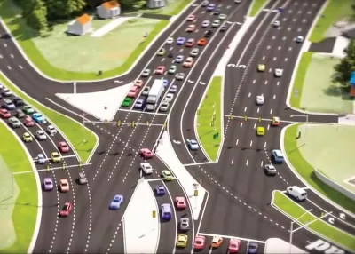
The Virginia County of Chesterfield is planning six so-called "superstreet" treatments for junctions in the county. One junction, where Route 10 meets Rivers Bend Boulevard, will cost $64 million.
Wyatt Gordon reports on transportation planning efforts from Chesterfield County in Virginia, which stands as a counterpoint of car-centric priorities compared to the recent public transit successes of the neighboring city of Richmond.
"Over the next decade Chesterfield plans to transform at least six of its widest junctions into so-called 'superstreets,' multi-lane behemoths that shift the flow of traffic from perpendicular designs to 15-lane-wide, swooping intersections," writes Gordon.
One of those junctions planned for the superstreet treatment also sets a lofty standard for expense, pricing out an estimated $64 million, which has some in the state questioning the wisdom of this kind of road engineering.
The relationship between Richmond and Chesterfield County is more than just a question of proximity: Both own half of the Greater Richmond Transit Company (GRTC), and the price tag for one $64 million intersection outpaces the entire region's spending on the GRTC, reports Gordon.
FULL STORY: Chesterfield County plans one intersection with a monster price tag

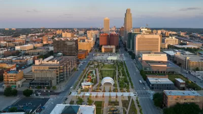
Downtown Omaha Planning for its Post-One-Way-Streets Era
The Omaha City Council has decided to reverse the transportation model adopted in the city in the 1950s, for the benefit of traffic safety and local retail activity.
Redesigning Streets for Livability: A Global View
An excerpt from the introduction of the recent book, “Streets For All: 50 Strategies for Shaping Resilient Cities,” edited by Vinayak Bharne and Shyam Khandekar.
Washington State Moving Ahead With Complete Streets
Move Ahead Washington, a law approved by the Washington State Legislature earlier this year, is expected to have a huge effect on transportation planning and engineering on state-controlled roads.

Planetizen Federal Action Tracker
A weekly monitor of how Trump’s orders and actions are impacting planners and planning in America.

Congressman Proposes Bill to Rename DC Metro “Trump Train”
The Make Autorail Great Again Act would withhold federal funding to the system until the Washington Metropolitan Area Transit Authority (WMATA), rebrands as the Washington Metropolitan Authority for Greater Access (WMAGA).

DARTSpace Platform Streamlines Dallas TOD Application Process
The Dallas transit agency hopes a shorter permitting timeline will boost transit-oriented development around rail stations.

San Francisco's School District Spent $105M To Build Affordable Housing for Teachers — And That's Just the Beginning
SFUSD joins a growing list of school districts using their land holdings to address housing affordability challenges faced by their own employees.

Car-Centric LA Suburb Looks to a Train-Oriented Future
City leaders in Rancho Cucamonga, the future western terminus of the Brightline West rail line to Las Vegas, want to reimagine the city as a transit-oriented, pedestrian-friendly community.

New Alaska Bitcoin Mine Would Burn as Much Energy as the State’s Largest Coal Plant
Fueled by “stranded” natural gas, the startup hopes to become the largest in the US, and to make Alaska an industry center.
Urban Design for Planners 1: Software Tools
This six-course series explores essential urban design concepts using open source software and equips planners with the tools they need to participate fully in the urban design process.
Planning for Universal Design
Learn the tools for implementing Universal Design in planning regulations.
Municipality of Princeton
Roanoke Valley-Alleghany Regional Commission
City of Mt Shasta
City of Camden Redevelopment Agency
City of Astoria
Transportation Research & Education Center (TREC) at Portland State University
US High Speed Rail Association
City of Camden Redevelopment Agency
Municipality of Princeton (NJ)