


Transportation and land use are being considered together at a new scale in the Bay Area, as transit oriented development pops up next to BART stations all over the region.
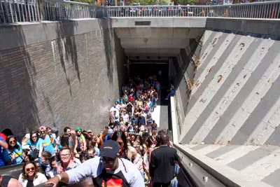
John King surveys the San Francisco Bay Area for examples of the transit-oriented building spree taking place near BART stations, like at MacArthur Station in Oakland:
A seven-story building with lime-green accents covers land that five years ago held parking lots. It’s part of a 385-unit apartment complex being marketed as “sleek and modern with a retro vibe ... perfect for your life on the go.” A few yards away, workers have nearly completed the concrete frame for a 24-story apartment tower that will open next spring.
In a feature story filed under "Bay Area Housing Crisis," King reports that projects have opened recently at seven East Bay BART stations, and projects at three more that could break ground soon. "Cities across the system are putting plans in place to allow bigger buildings near BART," writes King.
"Long touted by boosters as pedestrian-friendly 'transit villages,' such projects on BART-owned land are gaining traction as never before. The change is fueled by factors including the region’s incessant housing demand and a new state law that loosens development restrictions on BART property."
The idea of adding large buildings and large amounts of housing units to BART-adjacent properties has been occasionally controversial, but the recent development activity acts on planning goals set as long ago as 1972, and formalized by a formalized planning policy in 2005.
"The current policy, adopted in 2016, seeks to add up to 18,000 units by 2040, filling 250 acres at 27 stations," according to King. "It also sets a goal that 35% of these units should be reserved for below-market housing."
There is a lot more to see and consider in this big feature, with infographics, images, and soundbites that match the scale of the endeavor underway in the Bay Area.
FULL STORY: At home at BART

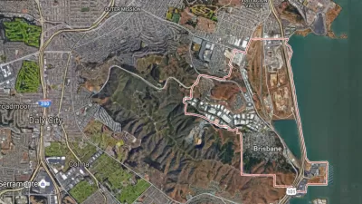
Voters Will Decide on Controversial Development Plans in Brisbane
A local issue with regional consequences: Measure JJ would approve a scaled back version of a development proposal at the Baylands site in the San Francisco suburb of Brisbane.
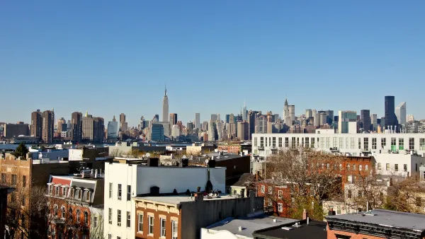
NYC Council Approves Brooklyn Rezoning Plan
The Atlantic Avenue Mixed Use Plan includes infrastructure investments and could bring 4,600 new housing units to parts of Brooklyn.
Bill to Allow Smaller Homes on Smaller Lots Resurrected in Texas House
A top priority of Lt. Gov. Dan Patrick, the legislation would make it easier to construct homes on smaller lots. A House Democrat briefly killed the bill.

Planetizen Federal Action Tracker
A weekly monitor of how Trump’s orders and actions are impacting planners and planning in America.

Congressman Proposes Bill to Rename DC Metro “Trump Train”
The Make Autorail Great Again Act would withhold federal funding to the system until the Washington Metropolitan Area Transit Authority (WMATA), rebrands as the Washington Metropolitan Authority for Greater Access (WMAGA).

DARTSpace Platform Streamlines Dallas TOD Application Process
The Dallas transit agency hopes a shorter permitting timeline will boost transit-oriented development around rail stations.

Renters Now Outnumber Homeowners in Over 200 US Suburbs
High housing costs in city centers and the new-found flexibility offered by remote work are pushing more renters to suburban areas.

The Tiny, Adorable $7,000 Car Turning Japan Onto EVs
The single seat Mibot charges from a regular plug as quickly as an iPad, and is about half the price of an average EV.

Supreme Court Ruling in Pipeline Case Guts Federal Environmental Law
The decision limits the scope of a federal law that mandates extensive environmental impact reviews of energy, infrastructure, and transportation projects.
Urban Design for Planners 1: Software Tools
This six-course series explores essential urban design concepts using open source software and equips planners with the tools they need to participate fully in the urban design process.
Planning for Universal Design
Learn the tools for implementing Universal Design in planning regulations.
Municipality of Princeton
Roanoke Valley-Alleghany Regional Commission
City of Mt Shasta
City of Camden Redevelopment Agency
City of Astoria
Transportation Research & Education Center (TREC) at Portland State University
US High Speed Rail Association
City of Camden Redevelopment Agency
Municipality of Princeton (NJ)