


Analyzing the potential outcomes of Senate Bill 10, one of two statewide upzoning bills under consideration in the state of Oregon this year.

Michael Andersen digs into the details of one of the big land use bills under consideration in the Oregon Legislature—SB 10, which would "legalize hundreds of thousands of potential future homes, almost all of them in three urban areas: Portland, Eugene-Springfield, and Salem."
The bill would allow new levels of density around transit lines, and remove parking requirements for new development neat transit stops.
"There’s compelling logic to it," writes Andersen. "Oregonians have spent billions of dollars on their mass transit systems and spend more than a billion more every year. Why not let people live near them if they want to?"
The bill would have especially broad reach in Portland, where TriMet has mapped the areas of the city that would be affected by the zoning changes mandated by Senate Bill 10 (click through to see the map).
The bill offers a kind of sliding scale for the kinds of density that would be legalized, depending on the size of the city and the capacity of nearby transit lines. Andersen collects examples of the varying degrees of density that would be possible if the legislature approves the bill. (Senate Bill is not to be confused with House Bill 2001, which would end single-family zoning in all cities in the state with a population over 10,000.)
FULL STORY: HERE’S WHAT OREGON’S HUGE NEW TRANSIT HOUSING BILL WOULD LEGALIZE

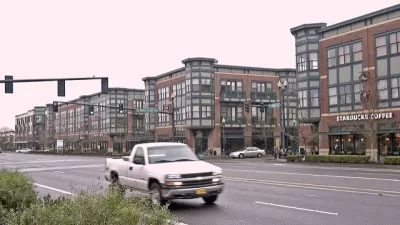
Oregon to Consider New Densities for Transit Adjacent Neighborhoods
The Oregon Legislature is already considering one of the most sweeping and ambitious statewide land use reform bills in the country. A new bill would allow even more density around transit stations.
South L.A. Townhall Opposes SB 1120 Statewide Upzoning Bill
L.A. City Councilmembers Herb Wesson and Paul Koretz register opposition to SB 1120, calling the bill an attack on the residential integrity throughout the state of California.
Virginia Upzoning and Accessory Dwelling Unit Bills Killed Quickly in Committee
The Land Use subcommittee of the Virginia House of Delegates decided quickly to uphold local control of zoning.

Planetizen Federal Action Tracker
A weekly monitor of how Trump’s orders and actions are impacting planners and planning in America.

Map: Where Senate Republicans Want to Sell Your Public Lands
For public land advocates, the Senate Republicans’ proposal to sell millions of acres of public land in the West is “the biggest fight of their careers.”

Restaurant Patios Were a Pandemic Win — Why Were They so Hard to Keep?
Social distancing requirements and changes in travel patterns prompted cities to pilot new uses for street and sidewalk space. Then it got complicated.

Platform Pilsner: Vancouver Transit Agency Releases... a Beer?
TransLink will receive a portion of every sale of the four-pack.

Toronto Weighs Cheaper Transit, Parking Hikes for Major Events
Special event rates would take effect during large festivals, sports games and concerts to ‘discourage driving, manage congestion and free up space for transit.”

Berlin to Consider Car-Free Zone Larger Than Manhattan
The area bound by the 22-mile Ringbahn would still allow 12 uses of a private automobile per year per person, and several other exemptions.
Urban Design for Planners 1: Software Tools
This six-course series explores essential urban design concepts using open source software and equips planners with the tools they need to participate fully in the urban design process.
Planning for Universal Design
Learn the tools for implementing Universal Design in planning regulations.
Heyer Gruel & Associates PA
JM Goldson LLC
Custer County Colorado
City of Camden Redevelopment Agency
City of Astoria
Transportation Research & Education Center (TREC) at Portland State University
Camden Redevelopment Agency
City of Claremont
Municipality of Princeton (NJ)