


In 1970, half of the city's census tracts were middle-income. Now, only 16 percent of them remain so. Polarization between the well-off and the poor essentially splits the city in two.

Researchers from the Nathalie P. Voorhees Center at the University of Illinois at Chicago have compiled a troubling set of maps showing how severely the city's middle class has shrunk over the past half-century.
"UIC's maps show that fully half of the city was middle income in 1970, including large swaths on every side of town," Linda Lutton writes. "Today, just 16 percent of the city's 797 census tracts are considered middle income. Those middle income areas are confined mostly to the corners of the city, and to thin strips between areas of wealth and poverty."
"Stubborn" racial segregation is one part of the story, as is the recent arrival of high-income households staking claims on the city's North Side. "Just 8 percent of Chicago's census tracts were considered high or very high income in 1970. Today, more than one-fifth of the city's census tracts are higher income." Low-income neighborhoods in the city's south and west tend to be majority black or Latino.
Meanwhile, says demographer Rob Paral, the North Side's rising affluence maps to education: people with higher degrees are replacing previous middle-class residents. Some affluent residents "buy half-million-dollar homes nearby that they tear down to use as side yards," according to a local realtor. "Two-flats, which middle-class families could afford because of the rental income, are now regularly converted to single-family homes," Lutton writes.
FULL STORY: The Middle Class Is Shrinking Everywhere — In Chicago It’s Almost Gone

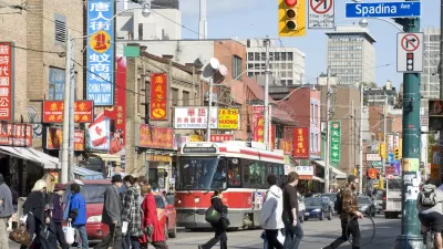
New Research Shows Toronto Highly Segregated Along Race and Class Lines
A closer look at the numbers reveals stark divides among Toronto neighborhoods.
Study: More Than Income, Race Influences Neighborhood Standards
Although income inequality receives plenty of coverage these days, research suggests that neighborhoods of color have less access to resources than white neighborhoods despite similar median incomes.
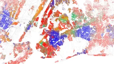
Examining the Surprising Segregation of New York City
The common perception of New York City is as of a well-integrated city, full of multi-ethnic neighborhoods. But a recent article peeks behind the curtain of the city’s surprising boundaries of racial segregation.

Planetizen Federal Action Tracker
A weekly monitor of how Trump’s orders and actions are impacting planners and planning in America.

Congressman Proposes Bill to Rename DC Metro “Trump Train”
The Make Autorail Great Again Act would withhold federal funding to the system until the Washington Metropolitan Area Transit Authority (WMATA), rebrands as the Washington Metropolitan Authority for Greater Access (WMAGA).

The Simple Legislative Tool Transforming Vacant Downtowns
In California, Michigan and Georgia, an easy win is bringing dollars — and delight — back to city centers.

The States Losing Rural Delivery Rooms at an Alarming Pace
In some states, as few as 9% of rural hospitals still deliver babies. As a result, rising pre-term births, no adequate pre-term care and harrowing close calls are a growing reality.

The Small South Asian Republic Going all in on EVs
Thanks to one simple policy change less than five years ago, 65% of new cars in this Himalayan country are now electric.

DC Backpedals on Bike Lane Protection, Swaps Barriers for Paint
Citing aesthetic concerns, the city is removing the concrete barriers and flexposts that once separated Arizona Avenue cyclists from motor vehicles.
Urban Design for Planners 1: Software Tools
This six-course series explores essential urban design concepts using open source software and equips planners with the tools they need to participate fully in the urban design process.
Planning for Universal Design
Learn the tools for implementing Universal Design in planning regulations.
Smith Gee Studio
City of Charlotte
City of Camden Redevelopment Agency
City of Astoria
Transportation Research & Education Center (TREC) at Portland State University
US High Speed Rail Association
City of Camden Redevelopment Agency
Municipality of Princeton (NJ)