


An interactive map shows the surprising density of the Garden State.
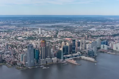
"The Garden State is home to the top four most densely populated municipalities in the United States, and seven of the top 10," according to this article by Stephen Stirling.
In fact, every good New Jersey resident is taught that the state is the densest state of all 50 United States, according to Stirling. "But some of the minutiae that make up that statewide statistic is staggering."
That's where an interactive map produced by NJ Advance Media for NJ.com comes in handy for illustrating the point. The visualization renders clearly the big four of density in the state—Guttenberg, Union City, West New York, and Hoboken—and the population groupings along the shore.
For the less populated corner of the state, look to the southwest, where Salem and Cumberland counties remain largely farmland. "But though the area remains largely farmland, communities have clustered around small, more tightly-packed community centers. Viewed in 3D, small but dense towns like Elmer, Bridgeton and Salem City stick out like sore thumbs," writes Stirling.
FULL STORY: 3D maps show parts of NJ are the most densely populated on the planet


Measuring Job Densification Trends in U.S. Metropolitan Areas
A new report details the trend of jobs densification in U.S. metropolitan areas between 2004 and 2015, finding a few large metropolitan areas leading an overall increase in jobs density. Still, many areas are seeing jobs disperse around the region.
Compare Transit Ridership in U.S. Cities
A new interactive tool called Transit Insights offers access to the local trends of transit ridership.

Pop Quiz: Can You Identify Cities By Density Alone?
A Planetizen editor failed this quiz.

Planetizen Federal Action Tracker
A weekly monitor of how Trump’s orders and actions are impacting planners and planning in America.

Congressman Proposes Bill to Rename DC Metro “Trump Train”
The Make Autorail Great Again Act would withhold federal funding to the system until the Washington Metropolitan Area Transit Authority (WMATA), rebrands as the Washington Metropolitan Authority for Greater Access (WMAGA).

DARTSpace Platform Streamlines Dallas TOD Application Process
The Dallas transit agency hopes a shorter permitting timeline will boost transit-oriented development around rail stations.

Renters Now Outnumber Homeowners in Over 200 US Suburbs
High housing costs in city centers and the new-found flexibility offered by remote work are pushing more renters to suburban areas.

The Tiny, Adorable $7,000 Car Turning Japan Onto EVs
The single seat Mibot charges from a regular plug as quickly as an iPad, and is about half the price of an average EV.

Supreme Court Ruling in Pipeline Case Guts Federal Environmental Law
The decision limits the scope of a federal law that mandates extensive environmental impact reviews of energy, infrastructure, and transportation projects.
Urban Design for Planners 1: Software Tools
This six-course series explores essential urban design concepts using open source software and equips planners with the tools they need to participate fully in the urban design process.
Planning for Universal Design
Learn the tools for implementing Universal Design in planning regulations.
Municipality of Princeton
Roanoke Valley-Alleghany Regional Commission
City of Mt Shasta
City of Camden Redevelopment Agency
City of Astoria
Transportation Research & Education Center (TREC) at Portland State University
US High Speed Rail Association
City of Camden Redevelopment Agency
Municipality of Princeton (NJ)