


With limited action at the state level, communities in vulnerable areas have launched their own local preparedness programs and plans.

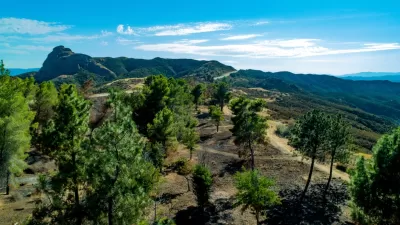
Doug Smith and Ben Welsh report on a Los Angeles Times analysis of buildings located in hazardous wildfire areas in California. "More than 1.1 million structures, or roughly 1 in 10 buildings in California, lie within the highest-risk fire zones in maps drawn by the Department of Forestry and Fire Protection, the analysis showed."
The highest concentration of these structures is in Los Angeles, where 114,000 homes, industrial buildings, and other buildings are located in high-risk areas. San Diego follows with 88,000 buildings. Areas where cities butt up against rocky terrain are the most vulnerable, note Smith and Welsh.
"Although they identify areas where stricter building standards and brush clearance are required, the maps do not directly trigger land-use restrictions or funds to make communities less vulnerable," say Smith and Welsh. The state mandates building codes, but retrofitting existing buildings and disaster preparedness remain largely the responsibility of local jurisdictions and fire departments.
Some communities in Southern California have taken the initiative to prepare for wildfires, where residents and local governments have organized volunteer arson watch and emergency response teams, conducted fire risk assessments, and held public meetings about safety and evacuation plans. However, many of these efforts still remain largely untested, since these are areas that were minimally affected by recent wildfires.
FULL STORY: A million California buildings face wildfire risk. ‘Extraordinary steps’ are needed to protect them

Resilient Communities, Healthy Ecosystems: A Balanced Approach to Wildfires
Effective wildfire mitigation in California requires a holistic approach that goes beyond large-scale vegetation removal, emphasizing home hardening, defensible space, strategic planning, and reducing human-caused ignitions.

California Faces Costly Measures in Preparing for Future Wildfires
In California, recovery after wildfires means many upfront investments by communities and the state.

Wildfire Risks Make Southern California Development a Gamble
The Tejon Ranch development would bring thousands of homes to a highly fire-prone area in L.A. County.

Planetizen Federal Action Tracker
A weekly monitor of how Trump’s orders and actions are impacting planners and planning in America.

Restaurant Patios Were a Pandemic Win — Why Were They so Hard to Keep?
Social distancing requirements and changes in travel patterns prompted cities to pilot new uses for street and sidewalk space. Then it got complicated.

Maui's Vacation Rental Debate Turns Ugly
Verbal attacks, misinformation campaigns and fistfights plague a high-stakes debate to convert thousands of vacation rentals into long-term housing.

In California Battle of Housing vs. Environment, Housing Just Won
A new state law significantly limits the power of CEQA, an environmental review law that served as a powerful tool for blocking new development.

Boulder Eliminates Parking Minimums Citywide
Officials estimate the cost of building a single underground parking space at up to $100,000.

Orange County, Florida Adopts Largest US “Sprawl Repair” Code
The ‘Orange Code’ seeks to rectify decades of sprawl-inducing, car-oriented development.
Urban Design for Planners 1: Software Tools
This six-course series explores essential urban design concepts using open source software and equips planners with the tools they need to participate fully in the urban design process.
Planning for Universal Design
Learn the tools for implementing Universal Design in planning regulations.
Heyer Gruel & Associates PA
JM Goldson LLC
Custer County Colorado
City of Camden Redevelopment Agency
City of Astoria
Transportation Research & Education Center (TREC) at Portland State University
Camden Redevelopment Agency
City of Claremont
Municipality of Princeton (NJ)