


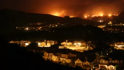
The Tejon Ranch development would bring thousands of homes to a highly fire-prone area in L.A. County.

A large proposed development in Tejon Ranch, north of Los Angeles, is raising concerns about building in an area considered at high risk of wildfires. The Centennial project would include more than 19,000 houses, which will be located in a grasslands area where fires can start and move quickly.
The developer, Tejon Ranch Company, and L.A. County planning staff say precautions can be put into place to minimize the wildfire threat, writes Nina Agrawal:
Because Centennial falls within state-designated fire hazard zones, homes will be built according to the most stringent codes, requiring flame-resistant roofing, attic vents with mesh screens, and double-pane, tempered glass windows. Homeowners must also clear brush within a certain radius on their properties.
But fire and ecology experts are skeptical. “Even if all the houses are designed exactly to code, [Michele] Steinberg said, they have to be maintained perfectly, with no dry leaves accumulating in gutters, cracks seeping between tiles or wooden decks tacked onto houses,” reports Agrawal.
The county's regional planning commission supports the project, and the proposal moves next to the board of supervisors this week. It could still be voted down, but the wildfire issue probably will not be the proposal’s downfall. “[Mitch] Glaser said he was not aware of any development in L.A. County that had been rejected wholesale because of fire hazard, though at least one had been downsized because of it,” notes Agrawal.
FULL STORY: L.A. County considers building a new city where fire hazard is high. Is Tejon Ranch worth the risk?

Wildfires Threaten Over a Million California Structures in High-Risk Areas
With limited action at the state level, communities in vulnerable areas have launched their own local preparedness programs and plans.

Resilient Communities, Healthy Ecosystems: A Balanced Approach to Wildfires
Effective wildfire mitigation in California requires a holistic approach that goes beyond large-scale vegetation removal, emphasizing home hardening, defensible space, strategic planning, and reducing human-caused ignitions.
Between a Rock and a Hard Place: Housing and Fire Safety in California
A proposed development near the site of the devastating Camp Fire highlights the growing tension between building badly needed housing and protecting communities from heightened wildfire risk.

Planetizen Federal Action Tracker
A weekly monitor of how Trump’s orders and actions are impacting planners and planning in America.

Maui's Vacation Rental Debate Turns Ugly
Verbal attacks, misinformation campaigns and fistfights plague a high-stakes debate to convert thousands of vacation rentals into long-term housing.

Restaurant Patios Were a Pandemic Win — Why Were They so Hard to Keep?
Social distancing requirements and changes in travel patterns prompted cities to pilot new uses for street and sidewalk space. Then it got complicated.

In California Battle of Housing vs. Environment, Housing Just Won
A new state law significantly limits the power of CEQA, an environmental review law that served as a powerful tool for blocking new development.

Boulder Eliminates Parking Minimums Citywide
Officials estimate the cost of building a single underground parking space at up to $100,000.

Orange County, Florida Adopts Largest US “Sprawl Repair” Code
The ‘Orange Code’ seeks to rectify decades of sprawl-inducing, car-oriented development.
Urban Design for Planners 1: Software Tools
This six-course series explores essential urban design concepts using open source software and equips planners with the tools they need to participate fully in the urban design process.
Planning for Universal Design
Learn the tools for implementing Universal Design in planning regulations.
Heyer Gruel & Associates PA
JM Goldson LLC
Custer County Colorado
City of Camden Redevelopment Agency
City of Astoria
Transportation Research & Education Center (TREC) at Portland State University
Jefferson Parish Government
Camden Redevelopment Agency
City of Claremont