


Plans to extend Milwaukee's The Hop streetcar line are still years away from fruition, but the city is already at work on development plans to make the most of the opportunity.
"While the actual extension of The Hop to the north and south is likely years away, the city has completed a planning process to study what development around stops in Bronzeville and Walker’s Point should look like," reports Jeramey Jannene.
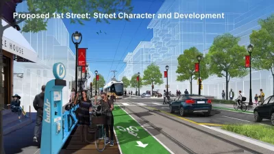
The Department of City Development presented the transit oriented development plan to the City Plan Commission earlier this week. The plan is designed "to extend investment from Downtown, connecting neighborhoods physically and economically, to enhance the local distinctiveness of neighborhoods and ensure that the existing communities benefit from any extensions through equitable and inclusive strategies," according to Jannene. To take effect, the new transit oriented development plans would be incorporated into area plans for Walker's Point and Bronzeville.
The plan prepared for Walker’s Point includes 1,500 to 2,000 new homes (primarily through multi-family buildings), 10 to 20 new storefronts and 3,000 to 4,000 new jobs primarily through the creation of new office space throughout the corridor.
The Bronzeville plan envisions 1,500 to 2,000 new homes, 20 to 30 new storefronts and 1,500 to 2,500 new jobs. The plan also envisions up to four new community facilities in the corridor. Most of the development is envisioned to happen near two intersections, where N. Martin Luther King Jr. Dr. intersects with W. North Ave. and with W. McKinley Ave. Both intersections have seen increased development in recent years including the Bucks arena district just south of W. McKinley Ave. and a host of projects along W. North Ave. including the Pete’s Fruit Market grocery store and The Griot apartments.
Those kinds of goals would require increased building heights. Skidmore, Owings and Merrill is the lead consultant on the plan. A lot more details are included in the source article.
FULL STORY: New Development Plans for Streetcar


Project Team for Milwaukee's New Downtown Area Plan Takes Shape
A new plan for Milwaukee's downtown will build on a "major renaissance" in the area since the approval of the last version of the plan in 2010.

Downtown Milwaukee Area Plan Update Kicks Off
Billions of dollars in investment and thousands of new residential units later, Milwaukee is ready to update the plan for its downtown.

'The Hop' Streetcar Opens to the Public Today in Milwaukee
The Hop will deliver new transit service on the east side of downtown Milwaukee. The Hop comes also serves big development expectations from local officials.

Planetizen Federal Action Tracker
A weekly monitor of how Trump’s orders and actions are impacting planners and planning in America.

San Francisco's School District Spent $105M To Build Affordable Housing for Teachers — And That's Just the Beginning
SFUSD joins a growing list of school districts using their land holdings to address housing affordability challenges faced by their own employees.

The Tiny, Adorable $7,000 Car Turning Japan Onto EVs
The single seat Mibot charges from a regular plug as quickly as an iPad, and is about half the price of an average EV.

San Diego Votes to Rein in “Towering” ADUs
City council voted to limit the number of units in accessory buildings to six — after confronting backyard developments of up to 100 units behind a single family home.

Texas Legislature’s Surprising Pro-Housing Swing
Smaller homes on smaller lots, office to apartment conversions, and 40% less say for NIMBYs, vote state lawmakers.

Even Edmonton Wants Single Staircase Buildings
Canada's second most affordable major city joins those angling to nix the requirement for two staircases in multi-family buildings.
Urban Design for Planners 1: Software Tools
This six-course series explores essential urban design concepts using open source software and equips planners with the tools they need to participate fully in the urban design process.
Planning for Universal Design
Learn the tools for implementing Universal Design in planning regulations.
Smith Gee Studio
City of Charlotte
City of Camden Redevelopment Agency
City of Astoria
Transportation Research & Education Center (TREC) at Portland State University
City of Camden Redevelopment Agency
Municipality of Princeton (NJ)