


The roads in your city might conform to a grid, or they might divert around natural resources or landmarks. A new tool aims to help you visualize the "hidden logic" behind urban growth.
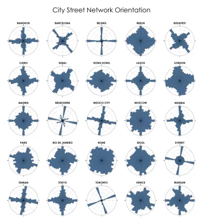
"It works by using an old geography technique: the 'polar' or circular chart. Boeing's tool calculates what percentage of a city's roads run along each section of a compass, and plots it on a circular bar chart."
Because the majority of streets in Manhattan, for example, align along a grid, its network is primarily encompassed in four long bars radiating out from the center of the circle. A few shorter bars represent the smaller portion of streets that don't line up.
Montgomery notes that a similar concept was created recently by data scientist Seth Kadish, but Boeing's adaptation made the model usable by anyone with knowledge of the programming language Python. Developer Vladimir Agafonkin built on Boeing's work to build a version for web browsers, so that "anyone can use a typical web mapping interface to visit any city or other region in the world and see a polar chart of its street grid."
"'It's a wonderful way to explore how cities are built; understand their hidden patterns and influences,' said Agafonkin. 'You can see where a road network was meticulously planned and where it grew naturally. [You can] see subtle connections like terrain, water bodies and nearby attractions influencing the direction of roads.'"
FULL STORY: Visualizing the Hidden ‘Logic’ of Cities

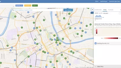
Presenting Municipal Data in an Interactive Map, Nashville Style
The city of Nashville launched the NashView interactive data map earlier this month.
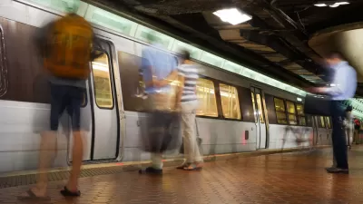
Metrorail Travel Patterns Revealed
Commute data for one of the nation's premier rail transit systems, revealed.

How the National Park Service Uses GIS
A new book demonstrates how the National Park Service uses GIS technology to meet its mission and showcases a selection of maps used for effectively managing national parks.

Planetizen Federal Action Tracker
A weekly monitor of how Trump’s orders and actions are impacting planners and planning in America.

Congressman Proposes Bill to Rename DC Metro “Trump Train”
The Make Autorail Great Again Act would withhold federal funding to the system until the Washington Metropolitan Area Transit Authority (WMATA), rebrands as the Washington Metropolitan Authority for Greater Access (WMAGA).

The Simple Legislative Tool Transforming Vacant Downtowns
In California, Michigan and Georgia, an easy win is bringing dollars — and delight — back to city centers.

The States Losing Rural Delivery Rooms at an Alarming Pace
In some states, as few as 9% of rural hospitals still deliver babies. As a result, rising pre-term births, no adequate pre-term care and harrowing close calls are a growing reality.

The Small South Asian Republic Going all in on EVs
Thanks to one simple policy change less than five years ago, 65% of new cars in this Himalayan country are now electric.

DC Backpedals on Bike Lane Protection, Swaps Barriers for Paint
Citing aesthetic concerns, the city is removing the concrete barriers and flexposts that once separated Arizona Avenue cyclists from motor vehicles.
Urban Design for Planners 1: Software Tools
This six-course series explores essential urban design concepts using open source software and equips planners with the tools they need to participate fully in the urban design process.
Planning for Universal Design
Learn the tools for implementing Universal Design in planning regulations.
Smith Gee Studio
City of Charlotte
City of Camden Redevelopment Agency
City of Astoria
Transportation Research & Education Center (TREC) at Portland State University
US High Speed Rail Association
City of Camden Redevelopment Agency
Municipality of Princeton (NJ)