


Commute data for one of the nation's premier rail transit systems, revealed.

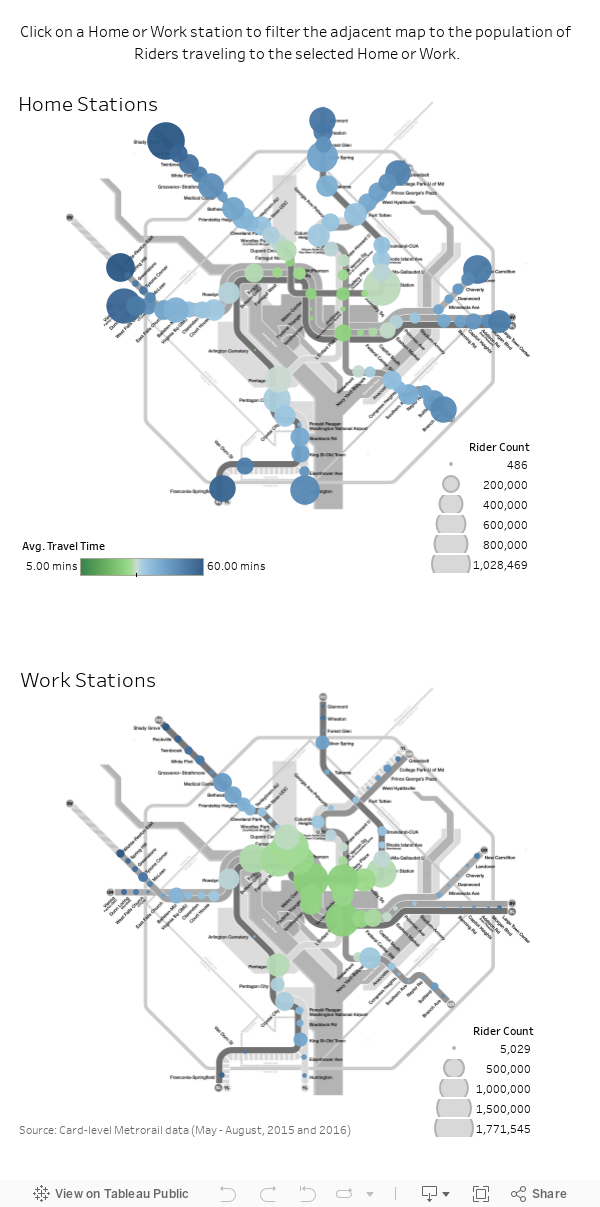
Sam Winward explains a series of maps he made that show how people use the Metrorail system in the Washington, D.C. region.
I used WMATA's ridership data to identify “Home” and “Work” stations based on individual ridership patterns. If a commuter leaves one station most mornings and returns to the same station in the afternoon, then this is their “Home” station. Their “Work” station is where they traveled to in the morning and left from in the afternoon.
And voilà: a series of maps that allows an exploration of the commute patterns of an entire region.
Winward made the maps available to share, but you'll have to click though to the original article to more about the methodology, how to use the map, and some of the conclusions Winward draws from the data visualization.
FULL STORY: These interactive maps show how and where people travel on Metro


Chart Your City's Street Network to Understand its Logic
The roads in your city might conform to a grid, or they might divert around natural resources or landmarks. A new tool aims to help you visualize the "hidden logic" behind urban growth.

Presenting Municipal Data in an Interactive Map, Nashville Style
The city of Nashville launched the NashView interactive data map earlier this month.

'Housing Insights' Mapping Tool Designed to Preserve Subsidized Housing in D.C.
The Housing Insights team of volunteer civic hackers hopes you'll use their software in other cities, too.

Planetizen Federal Action Tracker
A weekly monitor of how Trump’s orders and actions are impacting planners and planning in America.

Chicago’s Ghost Rails
Just beneath the surface of the modern city lie the remnants of its expansive early 20th-century streetcar system.

Amtrak Cutting Jobs, Funding to High-Speed Rail
The agency plans to cut 10 percent of its workforce and has confirmed it will not fund new high-speed rail projects.

Ohio Forces Data Centers to Prepay for Power
Utilities are calling on states to hold data center operators responsible for new energy demands to prevent leaving consumers on the hook for their bills.

MARTA CEO Steps Down Amid Citizenship Concerns
MARTA’s board announced Thursday that its chief, who is from Canada, is resigning due to questions about his immigration status.

Silicon Valley ‘Bike Superhighway’ Awarded $14M State Grant
A Caltrans grant brings the 10-mile Central Bikeway project connecting Santa Clara and East San Jose closer to fruition.
Urban Design for Planners 1: Software Tools
This six-course series explores essential urban design concepts using open source software and equips planners with the tools they need to participate fully in the urban design process.
Planning for Universal Design
Learn the tools for implementing Universal Design in planning regulations.
Caltrans
City of Fort Worth
Mpact (founded as Rail~Volution)
City of Camden Redevelopment Agency
City of Astoria
City of Portland
City of Laramie