


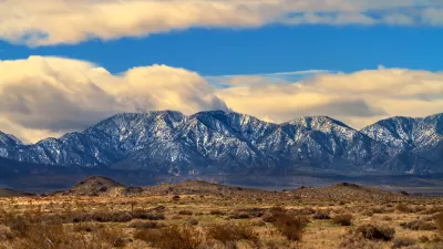
President Biden just signed a proclamation to expand the San Gabriel Mountains National Monument by over 100,000 acres.
Last week, President Biden took action to expand the San Gabriel Mountains National Monument, which President Obama designated in 2014. The proclamation adds 105,919 acres of U.S. Forest Service lands to the south and west of the Monument’s 346,177 acres, protects additional cultural, scientific, and historic objects, and expands access to outdoor recreation on public lands.
The lands added to the San Gabriel Mountains National Monument contain unique cultural, geological, and ecological resources. A diversity of animals, birds, reptiles, and other wildlife, including numerous sensitive, threatened, and endangered species, live among the unique geological and ecological features of the area, including its unusual canyons, chaparral and coastal sage scrub lands, riparian woodlands, and conifer forests. These lands are also homes to some of California’s most imperiled and iconic birds, including the endangered California condor. The area includes key habitats that support wetland-dependent plant species, sensitive fish and amphibians, and migration corridors. In addition, the area is geologically significant, with the landscape of the San Gabriel Mountains shaped by massive geologic forces over hundreds of millions of years.
As reported by Alex Wigglesworth, this expansion has been widely praised by the Indigenous leaders, politicians, conservationists, and community organizers who had long fought for the enlargement of the protected natural area which serves as the backyard of the Los Angeles Basin. The San Gabriel Mountains National Monument is within an hour’s drive of 18 million people.
To learn more, please read the source article.
FULL STORY: San Gabriel Mountains National Monument expands by more than 100,000 acres


Feds Weigh Expansion of San Gabriel Mountains National Monument
The White House is sending a top-level cabinet member who oversees the U.S. Forest Service to the San Gabriel Valley east of Los Angeles to hear public comments on the proposed expansion the San Gabriel Mountains National Monument.
Growing Support for Expanding the San Gabriel Mountains National Monument
Members of Congress are proposing an expansion to the national monument by over 109,000 acres, increasing its size by nearly a third.
Key Wins for Conservation in 2024
The year brought some important victories to advocates for public lands, national monuments, and the reclamation of Indigenous history.

Planetizen Federal Action Tracker
A weekly monitor of how Trump’s orders and actions are impacting planners and planning in America.

Map: Where Senate Republicans Want to Sell Your Public Lands
For public land advocates, the Senate Republicans’ proposal to sell millions of acres of public land in the West is “the biggest fight of their careers.”

Restaurant Patios Were a Pandemic Win — Why Were They so Hard to Keep?
Social distancing requirements and changes in travel patterns prompted cities to pilot new uses for street and sidewalk space. Then it got complicated.

Platform Pilsner: Vancouver Transit Agency Releases... a Beer?
TransLink will receive a portion of every sale of the four-pack.

Toronto Weighs Cheaper Transit, Parking Hikes for Major Events
Special event rates would take effect during large festivals, sports games and concerts to ‘discourage driving, manage congestion and free up space for transit.”

Berlin to Consider Car-Free Zone Larger Than Manhattan
The area bound by the 22-mile Ringbahn would still allow 12 uses of a private automobile per year per person, and several other exemptions.
Urban Design for Planners 1: Software Tools
This six-course series explores essential urban design concepts using open source software and equips planners with the tools they need to participate fully in the urban design process.
Planning for Universal Design
Learn the tools for implementing Universal Design in planning regulations.
Heyer Gruel & Associates PA
JM Goldson LLC
Custer County Colorado
City of Camden Redevelopment Agency
City of Astoria
Transportation Research & Education Center (TREC) at Portland State University
Camden Redevelopment Agency
City of Claremont
Municipality of Princeton (NJ)