


With a patchwork of management and local agencies involved, the imperiled rail corridor has no unified plan for improving or relocating tracks impacted by coastal erosion.
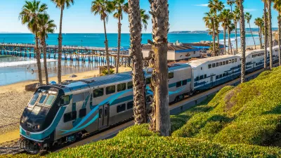
The rail corridor spanning 351 miles between San Luis Obispo and San Diego on the Southern California coast faces an uncertain future as erosion and sea level rise threaten the coastline that much of the tracks run along. As Melanie Curry explains in Streetsblog California, the line “serves as an important passenger connection for points between Santa Barbara and San Diego, and the route is also a key freight corridor, directly serving the ports of San Diego and Port Heuneme [sic].”
With the southern end of the corridor “closed more than it’s been open” in the last few months, “The [California] legislature this year formed a subcommittee to discuss the considerable problems facing this crucial rail route, and today held a second hearing on the topic (the first was held in May).”
The subcommittee didn’t reach any conclusions about how to move forward, Curry adds. “Further threats from sea level rise and rain seepage will continue their inexorable work to erode the cliffs. And a very wide range of agencies and operators have some role in maintaining rails and service, and in planning future work - but there is no clear leader.” Curry notes that “Most of the emergency work over the last 23 months has been in response to landslides from properties owned by private individuals above the cliffs, and has ranged from building retaining walls to adding riprap and sand along the coast.”
Darrel Johnson, the CEO of Orange County Transportation Authority (OCTA), said it became obvious during the hearings that “that the state has a very clear process for highway emergencies. This does not exist for publicly owned railroads.”
FULL STORY: What Is to Become of Southern California’s Coastal Rail Corridor?


SoCal Leaders Debate Moving Coastal Rail Line
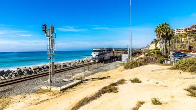
Train tracks running along the Pacific Ocean are in danger from sea level rise, but residents are divided on how to fix the problem.
Storms Sever California Rail Line—Again
The coast-hugging rail corridor linking Los Angeles and San Diego faces an uncertain future as mudslides once again force part of the line to close.

State Leaders Warn of Risks to Southern California Rail Corridor
Coastal erosion and rising sea levels threaten one of the nation’s most scenic—and strategically important—rail corridors.

Planetizen Federal Action Tracker
A weekly monitor of how Trump’s orders and actions are impacting planners and planning in America.

Restaurant Patios Were a Pandemic Win — Why Were They so Hard to Keep?
Social distancing requirements and changes in travel patterns prompted cities to pilot new uses for street and sidewalk space. Then it got complicated.

Maui's Vacation Rental Debate Turns Ugly
Verbal attacks, misinformation campaigns and fistfights plague a high-stakes debate to convert thousands of vacation rentals into long-term housing.

In California Battle of Housing vs. Environment, Housing Just Won
A new state law significantly limits the power of CEQA, an environmental review law that served as a powerful tool for blocking new development.

Boulder Eliminates Parking Minimums Citywide
Officials estimate the cost of building a single underground parking space at up to $100,000.

Orange County, Florida Adopts Largest US “Sprawl Repair” Code
The ‘Orange Code’ seeks to rectify decades of sprawl-inducing, car-oriented development.
Urban Design for Planners 1: Software Tools
This six-course series explores essential urban design concepts using open source software and equips planners with the tools they need to participate fully in the urban design process.
Planning for Universal Design
Learn the tools for implementing Universal Design in planning regulations.
Heyer Gruel & Associates PA
JM Goldson LLC
Custer County Colorado
City of Camden Redevelopment Agency
City of Astoria
Transportation Research & Education Center (TREC) at Portland State University
Camden Redevelopment Agency
City of Claremont
Municipality of Princeton (NJ)